How We Use Seafloor Mapping Data to Guide ROV Exploration! | Nautilus Live
Our current expedition to #JohnstonAtoll uses the mapping information gathered on our last expedition where we were able to map 27,788 square kilometers in and around this are of the #PacificRemoteIslandsMarineNationalMonument (PRIMNM). In this video, our #CorpsofExploration explain how we gather and use that #seafloormapping data and use it to determine where to dive with #ROVHercules.
Johnston Atoll is located in the #PrimeCrustZone, an area of the #Pacific with oceanographic conditions observed to concentrate deep-sea minerals, including economically valuable metals and rare earth elements. The questions of biological connectivity are particularly relevant around Johnston Atoll as the area contains rich biodiversity and is the closest deep water marine protected area to Papahānaumokuākea Marine National Monument and in the same region as the Kingman Reef, Palmyra Atoll, and Kiribati’s Phoenix Islands Protected Area. Thanks to our mapping team, scientists on this expedition can pinpoint the best places to dive for their geological and biological research.
Learn more about this expedition funded by NOAA Ocean Exploration via the Ocean Exploration Cooperative Institute: https://nautl.us/3Hx5pZE
--
E/V Nautilus is exploring unknown regions of the ocean seeking out new discoveries in biology, geology, and archaeology. Join us 24/7 for live video from the seafloor and to ask questions of our explorers currently aboard Nautilus: www.nautiluslive.org.
Follow us on social media for dive updates, expedition highlights, and more:
Subscribe on YouTube: www.youtube.com/subscription_center?add_user=EVNautilus
Facebook: www.facebook.com/nautiluslive
Twitter: www.twitter.com/evnautilus
Instagram: www.instagram.com/nautiluslive
TikTok: @NautilusLive
Видео How We Use Seafloor Mapping Data to Guide ROV Exploration! | Nautilus Live канала EVNautilus
Показать
Комментарии отсутствуют
Информация о видео
Другие видео канала
 Nautilus News Update - August 27, 2012
 Expedition Overview: Ocean Networks Canada | Nautilus Live
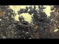 NAUTILUS LIVE 2012 | Eratosthenes Leg 3
 Navigator Career Profile | Nautilus Live
 NAUTILUS LIVE 2014 | NEW AMERICA in 60 Seconds
 Communication Wins! Updates from the Technology Integration Challenge | Nautilus Live
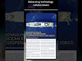 Read the Ocean Exploration Trust 2023 Field Season Report: https://bit.ly/3WEydsZ
 ROV Two-Body System with Todd Gregory | Nautilus Live
 Happy 50th Birthday Nautilus! | Nautilus Live
 Expedition Overview: Channel Islands in 60 Seconds
 Marine Biology & Genetics with Dr. Dan Distel | Nautilus Live
 Expedition Overview: Galapagos in 60 Seconds
 NAUTILUS LIVE 2014 | GISR in 60 Seconds
 Mapping Vocab Explainer: Hydrography & Cartography | Nautilus Live
 Expedition Overview: Greater Farallones in 60 Seconds
 NAUTILUS LIVE 2011 | Summary of Portugal Leg 6
 Sampling Ancient Underwater Volcanoes In the Pacific Remote Islands | Nautilus Live
 Expedition Overview: Cascadia Margin | Nautilus Live
 NAUTILUS LIVE 2012 | Biology of the Season
 Inspired by Nature: How sharks & marine mammals inspire future designs