- Популярные видео
- Авто
- Видео-блоги
- ДТП, аварии
- Для маленьких
- Еда, напитки
- Животные
- Закон и право
- Знаменитости
- Игры
- Искусство
- Комедии
- Красота, мода
- Кулинария, рецепты
- Люди
- Мото
- Музыка
- Мультфильмы
- Наука, технологии
- Новости
- Образование
- Политика
- Праздники
- Приколы
- Природа
- Происшествия
- Путешествия
- Развлечения
- Ржач
- Семья
- Сериалы
- Спорт
- Стиль жизни
- ТВ передачи
- Танцы
- Технологии
- Товары
- Ужасы
- Фильмы
- Шоу-бизнес
- Юмор
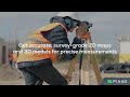
Pix4D - PIX4Dcatch RTK workflow for Accident Reconstruction
Need to map your scene with Accuracy and Efficiency?
DISCOVER THE PIX4Dcatch RTK workflow for Accident Reconstruction.
Easily scanning the damaged objects from the air and the ground, assessing the results, exporting to your 3rd party software and using the evidence in court.
PIX4Dcatch + viDoc + PIX4Dmatic
How does this work?
FIRST YOU CAPTURE:
0:17 Use a drone to map the overall scene
0:24 Use your phone to accurately capture the damaged car
0:31 Capture all details quickly and confidently with LiDAR and an intuitive UI.
0:34 Achieve centimeter-level position accuracy with RTK technology.
THEN YOU PROCESS THE DATA:
0:44 Merge drone and phone (LiDAR) data in the software
0:48 Take measurements easily
0:53 Inspect the digitally reconstructed scene
1:00 Combine ground based datasets with aerial imagery for a more complete and detailed model of the scene
AND THEN YOU EXPORT YOUR OUTPUTS:
1:11 Export models into industry-standard formats / Easily integrate into 3rd party software / Court-ready results
Learn more about Pix4D's offer for the Public Safety Industry: https://www.pix4d.com/public-safety/
Explore https://www.pix4d.com/discover-vidoc-rtk-rover-for-public-safety/
Видео Pix4D - PIX4Dcatch RTK workflow for Accident Reconstruction канала PIX4D
Комментарии отсутствуют
Информация о видео
3 июля 2023 г. 17:18:24
00:01:41
Другие видео канала