Chornobyl 1986: the first satellite picture of the disaster
Chornobyl 1986: the first satellite picture of the disaster as seen by Landsat 5.
The Landsat 5 image from April 29, 1986, was the first civilian satellite image of the accident. The data from Landsat were used to help confirm that an explosion had happened at Chornobyl and that the plant had been shut down.
Видео Chornobyl 1986: the first satellite picture of the disaster канала Студія Peredova
Показать
Комментарии отсутствуют
Информация о видео
Другие видео канала
 Благодійний аукціон «МИТЦІ – ВОЇНАМ» у Львові
 Тактична медицина: необхідність курсів підготовки
 Малюємо комікс. Частина 3: колір
 ВСЕ ДОБРЕ ШОУ (4) "Львів"
 Олег Павлюх | композитор
 Малюємо книжковий плакат.
 Малюємо комікс. Частина 2: контури
 Ріплей - Спогад (teaser)
 Малюємо етнографічний календар. Січень.
 Справа батьків
 Behance Portfolio Reviews. Анже Йереб.
 Ілюстрактор#3: Андрій Єрмоленко
 ПІНАП: Лекція Святослава Пащука
 Малюємо комікс. Частина 1: промальовка
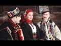 За кадром фотосесії "Гуцули"
 Последние Сигналы Четвёртого Энергоблока ЧАЭС
 50000 людей за 4 часа: объявление об эвакуации Припяти
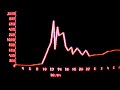 Уровень радиации в Киеве после аварии на Чернобыльской АЭС (26 апреля 1986)
 Каліграфічний майстер-клас від сестер Лопухіних
 Самый страшный телефонный разговор 20го века
 Ріплей - Спогад (Official Video)