Creating 2D and 3D Soil type maps in ArcGIS Pro
This video is a tutorial for creating 2D and 3D soil type maps from point data in ArcGIS Pro
.
The only thing you're going to need is an excel sheet of the boreholes with longitude, latitude and observed soil types of different depths.
In this example, we use Thiessen polygon method to interpolate soil data of an area from irregular point observations.
I also tried Kriging and IDW methods by classifying soil types into integer values but interpolation gives inaccurate results.
Webpage: https://berkanozgur.com
Instagram: https://www.instagram.com/beozgur/
Credits/
Music: https://www.bensound.com
Видео Creating 2D and 3D Soil type maps in ArcGIS Pro канала Berkan Özgür
Показать
Комментарии отсутствуют
Информация о видео
Другие видео канала
 How To Download Soil Map For Any Study Area And Classify The Soil Type
 Sharing 3D Content with Scene Layers
 ArcGIS Pro 3D Voxels
 Turn your borehole data into a complete exploratory 3D model in three easy steps
 Geocoding Addressees Using ArcGIS Pro
 🎨🗺🎨 DISEÑO de MAPAS en ArcGIS Pro #MiPrimerMapa con ArcGIS Pro - 04
 How to download FAO Digital Soil map
 A WPA Poster Style for ArcGIS Pro
 Slope, Aspect, Contour , Hillshade Map in ArcGIS
 Use Sentinel-2 Imagery with ArcGIS Pro (Change Detection)
 Geochemistry for ArcGIS 2.0
 Identifying potentially dangerous slopes on roads in ArcMap 10.6.1
 Iztech International Science Complex
 Creating a Cost Distance Friction Raster with Roads of Different Types
 Visualizing Data with Charts in ArcGIS Pro and ArcGIS Online
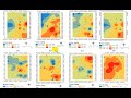 How to Prepare Spatial distribution map of Laboratory Results of collected samples in ArcGIS
 Tutorial N°16 : Building map 3D in Arcgis
 ArcGIS Pro 3D animation
 3D Analysis & Visualization in ArcGIS Pro
 ArcGIS Pro Attribute Rules - December 2020