MASSIVE MILE WIDE TORNADO Heading for Oklahoma City Metro !!!
Incredible mile wide tornado causes EF3 damage near Oklahoma City and incredible close footage of a stationary tornado near New Castle. for licensing contact hankschyma@yahoo.com
MAY 6, 2015 TORNADO OUTBREAK STORY:
At 1:25 PM a tornado watch was issued and by 2:50 PM, a small isolated thunderstorm was already producing several funnel clouds 60 miles southwest of Oklahoma City.
Powerful positive lightning activity was increasing near a classic merry-go-round base and a tight tornado briefly twisted to the ground. The storm was intensifying and the broader picture revealed a loaded gun scenario with Oklahoma City in its cross heirs.
RFD SURGE : SUPERCELL GETTING STRONGER AND STRONGER
The tornado cyclone circumference was expanding and funnels were writhing inside its curtains like a cage full of snakes
The RFD or Rear Flank Downdraft is a key mechanism in the formation of tornadoes in supercells and may include intense wind, rain and hail surging from the backside of the storm.
When storm chasers see strong wind and rain recirculating back into a developing tornado, they know it means trouble.
In this video a classic scenario of a powerful rear flank downdraft obscures an intensifying tornado in seconds. Unfortunately many people drive through RFD walls of rain only to meet their demise on the other side.
Strong RFD's can blow out windows and overturn vehicles. Large tornadoes can and often do change direction so driving through a powerful, blinding Rear flank Downdraft is a highly dangerous gamble even for veteran storm chasers.
MILE WIDE EF3
A mile wide tornado causing EF3 damage struck Bridge Creek Oklahoma, a small suburb less than 15 miles from heavily populated Norman.
Another unrated tornado developed near New Castle Oklahoma and remained stationary for several minutes before quickly dissipating, then the parent storm moved into Norman. The police were shut down streets and interstates while the city prepared for the worst.
NORMAN TRAFFIC
A confirmed EF1 tornado damaged west Norman. This storm would drop a couple more weak tornadoes in the Oklahoma City Metro area before transitioning into a high precipitation mess causing flooding. The Bridge Creek EF3 tornado tracked over 10 miles before stalling prior to entering a heavily populated area. Oklahoma City Metro dodged another bullet and could exhale in relief... but not for long... A new tornadic supercell would fire to the southwest and train over the previous storms path. It would enter Oklahoma City after dark and drop a destructive EF3 tornado injuring 12 people.
Видео MASSIVE MILE WIDE TORNADO Heading for Oklahoma City Metro !!! канала Pecos Hank
Показать
Комментарии отсутствуют
Информация о видео
Другие видео канала
 Insane Tornadoes
 El Reno Tornado 2013 - World's largest tornado - Storm Spotting Operations -
 THE ULTIMATE TORNADO UP CLOSE - Divine Tornado Conception 4K
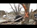 Discovery Channel Mile Wide Tornado Oklahoma Disaster HD
 GREATEST STORMS ON EARTH - Best Of Tornado Alley
 The first 10 minutes of the Moore EF5 Tornado (5/20/2013)
 TOO CLOSE TO EF4 TORNADO - Inside Debris Cloud in 4K
 2020 VIOLENT EF-4 TORNADO!! Ashby/Dalton, MN | Basehunters Chasing
 TORNADO DEATH TRAPS
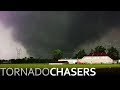 Tornado Chasers, S2 Episode 8: "Home, Part 2" 4K
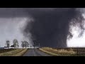 3 Hours of Tornadoes
 TORNADOES of 2016 - An Incredible Year in 4K!
 May 31st 2013 El Reno OK Tornado - New And Improved Footage!!
 DAY OF THE TWINS - Tornado terror in Nebraska
 Horrific EF-5 tornado in Moore, Oklahoma: May 20, 2013
 SCIENCE INSIDE A TORNADO - Decoding the EF5
 Crazy HUGE Tornadoes Caught On Tape | Extreme Tornado Compilation
 FASTEST MOVING TORNADO - New World Record
 AMAZING close-range tornadoes near Dodge City, KS on 5/24/2016 | Basehutners Chasing