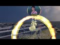
故宮館藏《坤輿全圖》之VR互動作品:坤輿藝境之說明短片 (2020)
“坤輿全圖”是比利時傳教士南懷仁於1674年繪製的古地圖,目前保存於國立故宮博物院。此一古地圖係由八長幅拼接而成,每一幅高171公分,寬52公分。地圖上主要繪製了東半球和西半球,而且在空白處還繪製了歐洲船舶以及近三十種海陸生物,包括:長頸鹿、鯨魚、變色龍等。
The ancient world map "Kun Yu Quan Tu" preserved in the National Palace Museum in Taipei was drawn in 1674 by Ferdinand Verbiest, a Belgian Jesuit missionary. This ancient map comprises eight long scroll paintings, each with a height of 171 cm and a width of 52 cm. The eastern and western hemispheres are drawn on the map. Also depicted in the map's blank area are European ships and nearly thirty species of land and sea creatures, including giraffe, whale, and chameleon.
南懷仁以這張世界地圖為輔助工具,向康熙皇帝介紹十六、十七世紀西方對於世界地理的概念,包含地圓說、世界無中心、雨雲、潮汐、地震等知識。
Ferdinand used this world map as an auxiliary tool to introduce to Emperor Kangxi the Western knowledge of world geography in the 16th and 17th centuries, including the concepts of spherical Earth, the world without a center, rain clouds, tides, and earthquakes.
Видео 故宮館藏《坤輿全圖》之VR互動作品:坤輿藝境之說明短片 (2020) канала Yi-Ping Hung
Показать
Комментарии отсутствуют
Информация о видео
Другие видео канала
 Quartic Flow VR -- Zeelandia 1634
 Interactive Multiresolution Browsing of GoogleMap on i-m-Top
 台大VR成果發表會:故宮秋色與敦煌飛天
 【TVBS】戴VR遊敦煌石窟 故宮台大聯手寫創舉
 台大昆達里尼瑜珈社2016秋季班空拍宣傳
 ACMMM 09, i-m-Tube
 台大社科院 空拍 2016April
 我已編輯的影片
 遨遊莫高61窟
 Smiling Buddha @ 2014 Ars Electronica in Linz
 微笑宇宙 SmileVerse
 UIST 2010: Enabling Beyond Surface Interactions (showcased at Siggraph 2010 E-Tech)
 Quartic Smiles 20160315
 風動四方-安平1634:國美館2017/11/03開幕記者會
 發現臺灣五千年─團圓篇 (Discovering the 5K years of Taiwan - the Reunion)
 故宮館藏《富春山居圖》之VR作品:神遊富春江VR製作說明短片 (January 2021)
 Walk into the Painting of "Autumn in Chiou and Hua Mountains" - 360 VR video
 Smiling Buddha @ 2014 Ars Electronica in Linz
 Flying in the Cave of Mogao 61 - 360 VR video
 走入鵲華秋色