- Популярные видео
- Авто
- Видео-блоги
- ДТП, аварии
- Для маленьких
- Еда, напитки
- Животные
- Закон и право
- Знаменитости
- Игры
- Искусство
- Комедии
- Красота, мода
- Кулинария, рецепты
- Люди
- Мото
- Музыка
- Мультфильмы
- Наука, технологии
- Новости
- Образование
- Политика
- Праздники
- Приколы
- Природа
- Происшествия
- Путешествия
- Развлечения
- Ржач
- Семья
- Сериалы
- Спорт
- Стиль жизни
- ТВ передачи
- Танцы
- Технологии
- Товары
- Ужасы
- Фильмы
- Шоу-бизнес
- Юмор
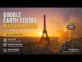
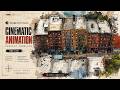
Colosseum Rome Aerial Orbit – Professional Map Animation Template | Google Earth Studio
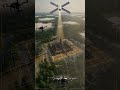
The camera starts above Rome, where the modern traffic grid wraps around older lines that never fully disappeared. The Colosseum sits just east of the Roman Forum, close to the line of the ancient Via Sacra. This was the political and ceremonial center of imperial Rome, and the amphitheater was placed here deliberately, on land reclaimed from Nero’s private lake.
The descent is slow and controlled. First orbit holds a wider radius, keeping the Forum, Arch of Constantine, and surrounding road network in frame. Second orbit tightens, dropping altitude to expose the internal seating tiers and substructure. Motion paths are stabilized with clean easing and consistent velocity.
HD 60fps. Adjustable FOV, sun angle, and haze. The geometry is simple. The context is not.
Free archive of cinematic Google Earth Studio map animation templates for creators, researchers, and storytellers.
Each project can be edited, retitled, and made your own. For filmmakers, students, and seekers of strange truths, these resources are free.
Colosseum Rome Aerial Orbit – Professional Map Animation Template | Google Earth Studio
https://drive.google.com/file/d/1YIpom9Wuu4nqSSZjJlIKNKaAmhooeJlp/view?usp=drive_link
Видео Colosseum Rome Aerial Orbit – Professional Map Animation Template | Google Earth Studio канала Google Earth Studio Map Template Vault
Комментарии отсутствуют
Информация о видео
22 ч. 57 мин. назад
00:02:53
Другие видео канала