Land Measurement Using Satellite | उपग्रह द्वारा जमीन की पैमाइश
आजकल उपग्रह के इस्तेमाल से जमीन की पैमाइश की जाती है । अनुभवी पटवारी भी मदद करते है । यह तकनीक और अनुभव का अध्भुत संगम है ।
संदीप जी ने यह तरीका समझाया ।
Видео Land Measurement Using Satellite | उपग्रह द्वारा जमीन की पैमाइश канала LIFE You Only Live Once
संदीप जी ने यह तरीका समझाया ।
Видео Land Measurement Using Satellite | उपग्रह द्वारा जमीन की पैमाइश канала LIFE You Only Live Once
Показать
Комментарии отсутствуют
Информация о видео
Другие видео канала
 ETS MACHINE : HOW TO MEASURE LAND
 DGPS survey Instrument Explained.
 How To Land Demarcation Work | Dgps Hi Target |
 Leica GS 14 DGPS setup & survey full detail
 GPS Land Meter Measurement Agriculture Measuring Tools High Accuracy Land Area Measuring Instrument
 GPS Surveying | Hand GPS | GPS survey instrument | GPS land survey
 Training DGPS GNSS Survey Full Practical Training on Static Survey Using TRIMBLE R2 TSC2
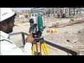 Total station Basic | Column marking with TS | Resection
 AUTO LEVEL SURVEYING
 High Accuracy Land Distance Area GPS Machine For Land Survey Built In Barometer
 फ्री में जमीन को GPS से कैसे नापे।। calculate GPS area or GPS distance with great accuracy
 How to DGPS Setup and Static Survey by Trimble R8s
 अब जमीन की मापी होगी मशीन से, न एक इंच इधर न उधर
 #vlog49 A day of surveyor's life||Drone survey||DGPS survey|Indian Open cast mine||aadi the explorer
 Part-1#Total Station Explanation with All Parts In Hindi
 Hi target V30 Plus Introduction Function & features
 Jarib Se Jamin Mapi Kaise Kare | Live Khet Mapi | Grand Teach
![iBell laser Meter [Unboxing and Review]](https://i.ytimg.com/vi/9W3oMd01-Ys/default.jpg) iBell laser Meter [Unboxing and Review]
iBell laser Meter [Unboxing and Review] Observe Topography Continuous data or measure fix points with GPS with fix time in اردو & हिंदी
 Demarcation of Land in Hindi. निशानदेही कैसे होती है? jamin kaise nape