Download Present and Future Climate Data 1901 to 2099
Today's topic is how to download climate data, both present and projected, from the World Bank website. You can get present climate data from as far back as 1901 up until 2021, as well as projected data up to the year 2099. I mean you will be able to download more than 100 years’ data and the best part is that all of this data can be downloaded free of charge. However, if you want to use this data, it's important to properly acknowledge the World Bank through citation.
#climatechange #climatedata #temperature #precipitation #arcgistutorial #dataanalysis
Link: https://climateknowledgeportal.worldbank.org/
Видео Download Present and Future Climate Data 1901 to 2099 канала GIS & RS Solution
#climatechange #climatedata #temperature #precipitation #arcgistutorial #dataanalysis
Link: https://climateknowledgeportal.worldbank.org/
Видео Download Present and Future Climate Data 1901 to 2099 канала GIS & RS Solution
Показать
Комментарии отсутствуют
Информация о видео
Другие видео канала
 Download, Install, and Perform Watershed Delineation with ArcHydro Tool
 Quantitative Risk Assessment of an Industry Using ALOHA Software: A Case Study
 How to Draw Automatic Duplicate Line in ArcGIS
 Air Quality Dispersion Modeling Tutorial 1: Download Software and Interface Overview
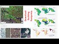 Download Latest Building/Built Up Area (Point or Polygon Shapefile) for any Location
 How to Calculate Volume of Reservoir/Lake/any waterbody using ArcGIS
 Clipping/Extracting Raster Data without Using any Shapefile in ArcGIS
 Identify Affected Structures for a Proposed Road Project Using ArcGIS
 Download Rainfall Data (Hourly, Daily, Monthly, Yearly), Data Processing & Map Preparation in ArcGIS
 Groundwater/Aquifer Level Map in ArcGIS
 How to Remove No Data/Black Background from Raster Images
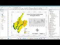 Assessment of Urban Heat Island (UHI) Using Remotely Sensed Imagery & GIS Technology
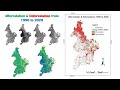 Deforestation & Afforestation Map from 1990 to 2020 Using ArcGIS
 How to Download Digital Surface Model (DSM) !! Which is best DSM or DEM?
 Excel to GIS Shapefile
 Google Earth Engine Tutorial 4: How to Download Landsat Image
 Google Earth Engine Tutorial 3: Visualizing Satellite Image
 Google Earth Engine Tutorial 2: How to collect Landsat Image
 Google Earth Engine Tutorial 1: Opening Account and Familiar with Script Editor and Datasets
 Visualizing Large Data through Pie, Bar, Stacked Charts in ArcMap (Data has given for Practice)