Army Corps of Engineers sonar maps Ohio River bottom
Barry Vessels explains a sonar to collect data from the Ohio River bottom to 5th and 6th Grade Magnate School students from Glasgow, Ky. The data helps barge captains in navigation. "Sometimes it feels like you are collecting data while riding a roller coaster that is pitched in every direction," said Barry Vessels, Lead Marine Information Specialist/Navigation, Army Corps of Engineers, Louisville. On the computer screen: The Marine Team use multibeam sonar that has 240 sonar beams collecting point cloud data along the bottom surface of the riverbed at 15 times a second. It uses a fan pattern from the 240 beams, with each sonar beam or sound wave sent out at ½ a degree cone. Think of a "fish finder" used on a fishing boat. That fishing boat sends out a single sonar beam typically at a 14-degree cone. The narrower cone of the survey grade sonar has a much smaller footprint showing finer detail of the object it strikes on the bottom. As the boat travels, it collects 240 points along the fan with a footprint that has a width about 3 times the depth. At 10 feet deep, the fan footprint along the bottom will be about 30 feet wide with the 240 point spread across even spaced. The sonar sends the data to the computer at an adjustable rate with most surveys using 15-20 times a second.
Видео Army Corps of Engineers sonar maps Ohio River bottom канала LouisvilleUSACE
Видео Army Corps of Engineers sonar maps Ohio River bottom канала LouisvilleUSACE
Показать
Комментарии отсутствуют
Информация о видео
Другие видео канала
 Anatomy of Tainter Gate
 USACE shares Proposed Plan at Camp Ellis
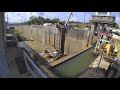 Time lapse of the McAlpine Locks and Dam Miter Gate Replacement Project
 Col. Gant and Linda Murphy discuss Women's History Month
 Falls of the Ohio
 Time-lapse at Olmsted - Lift Transport setdown Combine 2 min 8 sec
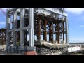 Monoliths on the move at Olmsted Locks and Dam
 LP1 Shell Movement at Olmsted Feb. 2011
 Army Corps of Engineers bridges the gap at Copeland, Ky.
 Nolin Lake levels have a positive impact
 Breeze - Cannelton Locks and Dam's new lock dog
 Louisville District provides technical assistance for debris removal in Bowling Green, Kentucky
 First tainter gate ready for shipment upriver to Olmsted project
 USACE Day at the Bats 2021
 Air Force Museum widens wingspan
 USACE Louisville Eastern Kentucky Mission
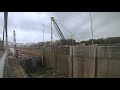 September Time Lapse of the McAlpine Locks and Dam Miter Gate Replacement Project
 Caesar Creek Lake Inspection - Sept. 23, 2019
 Mayfield Debris Removal Public Service Announcement
 Time-lapse at Olmsted Locks and Dam - Tremie concrete night day