82 Years of Beach Erosion - Time Lapse
Location: Old Lyme, CT coastal wetlands, 1934-2016. (Note to teachers: this video is NOT designed for use in elementary-age instruction or similar settings).
Photo #timelapse of #erosion with original music. Aerial view of re-shaping and land loss (with some deposition also visible) on the shoreline, beaches, and tidal salt marshes near the mouth of the Connecticut River at its juncture with the Long Island Sound. Local seaside landmarks affected include Griswold Point, the Black Hall River, Griswold Cove, White Sands beach, and Great Island (including Poverty Point). The video shows the levels of environmental impacts from multiple hurricanes, tropical storms, and other natural weather-related events to which the regional climate is susceptible and which accelerate the process, including the 1938 hurricane, Hurricane Carol, Hurricane Gloria, Hurricane Bob, Hurricane Irene, and Hurricane Sandy. Music: excerpt from "Belongings" for solo piano (audio: all rights reserved).
Видео 82 Years of Beach Erosion - Time Lapse канала johndante87
Показать
Комментарии отсутствуют
Информация о видео
Другие видео канала
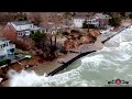 Houses Washing Away As Sea Walls Fail, Gale Force Winds Hit Ogden Dunes & River Walk, Drone 4K shots
 When a Mountain comes down... a Rockslide
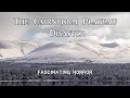 The Cairngorm Plateau Disaster | A Short Documentary | Fascinating Horror
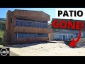 Massive Waves Destroy Beach House Wall and Patio (Raw Storm Footage)
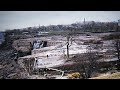 This Is What Scientists Found at the Bottom of the Niagara Falls That Left Them so Disturbed
 TERRIBLE TRUCK CRASH I-80 WYOMING (WAIT FOR IT)!
 Watch: Landslide Crushes a Home
 84 Years of Urbanization (Time Lapse)
 Watch: Pacifica Coastal Erosion 2021 Update
 You're F*$%ing Kidding Me
 Cliff erosion threatens to push California homes into sea
 BIRLING GAP 17-03-2014
 5 Monster Waves Caught On Camera
 Land O' Lakes, Florida Sinkhole - Updated Video
 Bay of Fundy Erosion Time Lapse
 The problems with rebuilding beaches
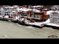 Everything Falling In! Long Beach Homes Being Taken Out By Storm surge! Crazy Storm drone footage 4K
 The Day The Gauge Changed
 Sea level rise is swallowing Puerto Rico's beaches
 Time-lapse video of bluff erosion on Barter Island, Alaska