Landslides triggered by Hurricane Maria: Assessment of an extreme event in Puerto Rico
During September 2017, Hurricane Maria triggered more than 70,000 slope failures throughout the mountainous regions of Puerto Rico (USA). Since then, the USGS has had a multi-faceted team working to understand landslide hazards in Puerto Rico. Using aerial imagery immediately after the hurricane, an island-wide inventory of the hurricane-induced landslides created in the following years, and detailed field studies of 123 landslides, we aim to gain insight into location-specific controls on landslide characteristics, sediment generation, and the consequent hazards. This talk will review past and on-going USGS work in Puerto Rico, and preview some new work from Utuado, where the landslide density was highest. In Utuado, we have begun pairing material properties, hydrologic measurements, land-use, and erosion rates with field mapping to understand the potential frequency, or conditions, of landslide recurrence. The goal is to understand the role of storm-driven landslides as immediate hazards as well as their role in longer-term tropical landscape evolution and weathering.
Cerovski-Darriau (2022) Landslides triggered by Hurricane Maria: Assessment of an extreme event in Puerto Rico. USGS Landslide Hazards Seminar, 18 May 2022.
Video: https://www.usgs.gov/media/videos/landslides-triggered-hurricane-maria-assessment-extreme-event-puerto-rico
Видео Landslides triggered by Hurricane Maria: Assessment of an extreme event in Puerto Rico канала USGS Presentations
Показать
Комментарии отсутствуют
Информация о видео
Другие видео канала
 Global Change Monitoring Portal: Pilot for the Southeast US
 Climate Change and Migratory Species Presentation (Jan 2009) -- Part 1 of 3
 High Resolution Climate Models to Benefit Avian Conservation
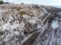 North Dakota landslide mapping: A complete inventory and mapping into the future
 PubTalk-01/2024: Ancient human footprints in North America during the Last Glacial Maximum
 Climate, Water Quality, Toxic Blooms of Golden Alga in Texas
 2017 October Evening Public Lecture — Global Trends in Mineral Commodity Supplies
 November Evening Public Lecture -- Waterbirds in a Changing Landscape
 Potential Corrosivity of Untreated Groundwater in the United States (Public Lecture)
 NextGen Water Data Update: Monitoring Location Pages & WaterAlert
 Atmospheric rivers cause the majority of precipitation-induced landslides in Western North America
 What's the Deal with Wisconsin's Walleye?
 WaterML2 Part 3: Surface Hydrology Features Conceptual Model and the Mainstems Logistical Data Model
 Global rainfall thresholds for urban landslides
 The building and upkeep of landslide hazards program: Blue Ridge perspective on a national challenge
 topoBuilder: OnDemand, Custom, Topographic Maps
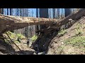 Post-fire debris flows in relation to observed rainfall anomalies: Dolan Fire, California
 Use of UASs (“Drones”) in 2018 at Kīlauea and Beyond
 Fish Habitat and Climate Change Part 1
 Climate Change, Mountain Pine Beetles, and Whitebark Pine
 Preparing for landslide disasters: Lessons learned from 20 years of USGS landslide response