EROSION RIO COCA
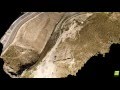
For more than a year as ANDES WAYPOINT we have been supporting the community with technical material obtained through the UAVs jointly with precision instruments and GNSS receivers. We have managed to map almost 11 Km from the implosion of San Rafael´s waterfall to the San Carlos town. This cartographic information helps to carry out a more precise monitoring of the development of this natural phenomenon.
The San Luis town is located in Napo province – Ecuador, this little town is the most affected just in March 2022 the following damages are registered, 68 people affected, 32 people evacuated, 45 families at risk and 193 people at imminent risk; in addition the collapse of 3 bridges that are part of the state road network that connects the country's capital with the Amazon region and in addition is also important to mention the collapse of almost 1.6 km of the road.
Видео EROSION RIO COCA канала Andes Waypoint
Показать
Комментарии отсутствуют
Информация о видео
Другие видео канала