Mapping the sea floor with the multibeam echosounder and the Moving Vessel Profiler
Jean-Guy and Gabriel make up the CCGS Amundsen’s mapping team. They use a Moving Vessel Profiler to measure different kinds of data such as speed of sound, temperature and dissolved oxygen content in the water. They also use a multibeam echosounder to create vivid 3-D maps of the Arctic sea floor.
This video is part of a multimedia feature on the Canadian research icebreaker. To tour the CCGS Amundsen, click on the link. http://www.innovation.ca/en/ResearchInAction/OutcomeStory/TourCCGSAmundsen
To watch the Amundsen playlist on YouTube, click this link.
https://www.youtube.com/watch?v=CmtjxTac4PI&list=PLy_LO21HROEBEAkknC-CqPhUQiaUs2uBz
The Canadian research icebreaker is open for business. Check out their listing on the CFI Navigator:
http://www.innovation.ca/en/navigator/CCGSAmundsen
Видео Mapping the sea floor with the multibeam echosounder and the Moving Vessel Profiler канала Canada Foundation for Innovation / Fondation canadienne pour l'innovation
Показать
Комментарии отсутствуют
Информация о видео
20 апреля 2015 г. 18:46:51
00:02:17
Другие видео канала
 Scientists "See" Ocean Floor via Sonar | National Geographic
 Furuno DFF3D Multi-Beam Sonar 3D Fish Finder
 Fugro Survey Multibeam Echosounder
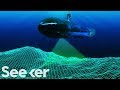 How Close Are We to Completely Mapping the Ocean?
 How Sonar Works
 Hydrography explained to kids
 Bathymetric survey of a lake using UAV drone with echosounder
 HYPACK 2020: Multibeam Tips and Tricks
 SeaBat T50-P Multibeam Echosounder
 Mapping the deep ocean: Geoscience Australia and the search for MH370
 Side Imaging® Tutorial Video
 Marine Echo Sounder
 Why the Atlantic and Pacific Oceans Don't Mix
 Mapping the Earth's ocean floor
 Hydrographic Survey with WASSP Multibeam Sonar
 Offshore Seismic Surveying
 The Moving Vessel Profiler and Multibeam Echosounder aboard the CCGS Amundsen
 WASSP G3 for TZ Professional - Marine Navigation Software (EN)
 Bathymetry Video Tutorial
 WASSP F3 Multibeam Sonar in Time Zero V3