- Популярные видео
- Авто
- Видео-блоги
- ДТП, аварии
- Для маленьких
- Еда, напитки
- Животные
- Закон и право
- Знаменитости
- Игры
- Искусство
- Комедии
- Красота, мода
- Кулинария, рецепты
- Люди
- Мото
- Музыка
- Мультфильмы
- Наука, технологии
- Новости
- Образование
- Политика
- Праздники
- Приколы
- Природа
- Происшествия
- Путешествия
- Развлечения
- Ржач
- Семья
- Сериалы
- Спорт
- Стиль жизни
- ТВ передачи
- Танцы
- Технологии
- Товары
- Ужасы
- Фильмы
- Шоу-бизнес
- Юмор
New Zealand Land Information WFS vectorial data in DWG
https://www.spatialmanager.com/
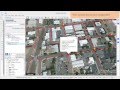
Access and import authoritative LINZ (Land Information New Zealand) vector datasets directly into your DWG through the LINZ WFS (Web Feature Service). Spatial Manager connects to the WFS endpoint, lists available features. Reproject on the fly to the active drawing Coordinate Reference System. No need to download and unzip intermediate files: features are streamed directly from the live WFS service and inserted as standard CAD entities you can snap to, analyze or export again. Keep your DWG up to date with the latest LINZ data.
Available for AutoCAD, BricsCAD, ZWCAD and GstarCAD
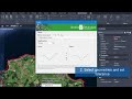
0:00 Register and create a free account for downloading LINZ data https://data.linz.govt.nz/accounts/register/
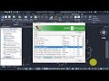
0:20 Open https://data.linz.govt.nz URL and login with the created user
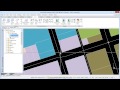
1:05 Explore catalog or search vectorial data sets
1:38 Add to the map and preview
2:04 Copy WFS URL in Service and APIs section
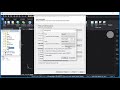
2:23 Execute SPM command, open palette and create WFS Data Source
2:44 Paste WFS URL and finish
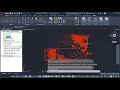
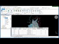
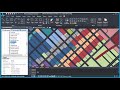
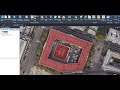
3:03 Expand and import vectorial layer
3:28 Review imported geometries and data
https://www.spatialmanager.com/linz-wfs/
Видео New Zealand Land Information WFS vectorial data in DWG канала Spatial Manager
Access and import authoritative LINZ (Land Information New Zealand) vector datasets directly into your DWG through the LINZ WFS (Web Feature Service). Spatial Manager connects to the WFS endpoint, lists available features. Reproject on the fly to the active drawing Coordinate Reference System. No need to download and unzip intermediate files: features are streamed directly from the live WFS service and inserted as standard CAD entities you can snap to, analyze or export again. Keep your DWG up to date with the latest LINZ data.
Available for AutoCAD, BricsCAD, ZWCAD and GstarCAD
0:00 Register and create a free account for downloading LINZ data https://data.linz.govt.nz/accounts/register/
0:20 Open https://data.linz.govt.nz URL and login with the created user
1:05 Explore catalog or search vectorial data sets
1:38 Add to the map and preview
2:04 Copy WFS URL in Service and APIs section
2:23 Execute SPM command, open palette and create WFS Data Source
2:44 Paste WFS URL and finish
3:03 Expand and import vectorial layer
3:28 Review imported geometries and data
https://www.spatialmanager.com/linz-wfs/
Видео New Zealand Land Information WFS vectorial data in DWG канала Spatial Manager
Комментарии отсутствуют
Информация о видео
26 мая 2026 г. 14:41:10
00:04:13
Другие видео канала