Tracking Typhoon Rolly (Bagyong Rolly) + Updates from PAGASA October 30 Bulletin
"ROLLY" ENTERS THE PHILIPPINE AREA OF RESPONSIBILITY (PAR) AND RAPIDLY INTENSIFIES INTO A TYPHOON.
Track and intensity outlook:
Track: "ROLLY" is forecast to move west-southwestward or southwestward tomorrow until Saturday evening. Afterwards, the typhoon will turn more west-northwestward as it moves over the sea off the coast of Bicol Region towards the eastern coast of Central Luzon-Quezon area. On the forecast track, the center of the eye of "ROLLY" is likely to make landfall over the Central Luzon-Quezon area on Sunday evening or Monday morning.
Intensity: "ROLLY" was upgraded to typhoon category at 8:00 PM today and has rapidly intensified over the last 24 hours. The typhoon is forecast to continuously intensify over the Philippine Sea and is likely to make landfall at peak intensity of 165-185 km/h.
Hazards affecting land areas:
Rainfall: Tonight through tomorrow morning, the trough of the typhoon will bring light to moderate with at times heavy rains over Bicol Region, Eastern Visayas, Central Visayas, and Caraga. The rainbands of the typhoon will likely bring rains over Bicol Region and the eastern section of Northern and Central Luzon beginning on Saturday or Sunday.
Strong winds: No locality is currently under Tropical Cyclone Wind Signal (TCWS) #1. However, in anticipation of the arrival of strong to near-gale conditions due to "ROLLY", TCWS #1 may be raised over several provinces in the Bicol Region as early as tomorrow. Given that it is likely for this typhoon to continue intensifying prior to landfall, the highest possible TCWS that will be raised throughout the passage of this typhoon will be TCWS #3 or #4 (associated with destructive to very destructive typhoon-force winds).
Hazards affecting coastal waters:
Rough to very rough seas (2.5 to 4.0 m) will be experienced over the seaboards of Batanes, Babuyan Islands, Ilocos Norte, and Ilocos Sur and the northern seaboard of mainland Cagayan due to the northeasterlies. A Gale Warning is in effect for these waters. As such, sea travel is risky over these areas, especially for mariners of small seacrafts.
Moderate to rough seas (1.2 to 2.5 m) will be experienced over the remaining seaboards of Northern Luzon. Mariners of small seacrafts are advised to take precautionary measures when venturing out to sea. Inexperienced mariners should avoid navigating in these conditions.
Information on international name:
This tropical cyclone uses the international name "GONI" (meaning: swan). The name was contributed by the Republic of Korea.
Other tropical systems being monitored:
At 8:00 PM today, the Tropical Depression outside the PAR has intensified into Tropical Storm "ATSANI". Its center was estimated at 2,430 km East of Mindanao (8.2 ºN, 148.4 ºE). It has maximum sustained winds of 65 km/h near the center and gustiness of up to 80 km/h. It is moving northward at 20 km/h. Based on all available meteorological data, this tropical cyclone is likely to enter the PAR on Sunday or Monday. However, it is less likely to bring severe weather over any locality of the country over the next 3 days. Once inside the PAR, "ATSANI" will be assigned the domestic name "SIONY".
Видео Tracking Typhoon Rolly (Bagyong Rolly) + Updates from PAGASA October 30 Bulletin канала Pinoy Tech Tips
Показать
Комментарии отсутствуют
Информация о видео
Другие видео канала
 What are hurricanes, typhoons and tropical cyclones?
 24 Oras: Bagyong Rolly, pumasok na sa Philippine Area of Responsibility kaninang hapon
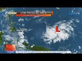 UB: Weather update as of 7:15 a.m. (Oct. 29, 2020)
 Typhoon Rolly (GONI) Updates from PAGASA 5 AM Bulletin October 30 + Info on Siony
 Formation Of A Tropical Cyclone
 Rainy weather ahead: La Niña likely in September or October, says PAGASA | Teleradyo
 Good Morning Kuya | October 30, 2020
 TV Patrol: 7 areas may experience signal number 4: PAGASAerience signal number 4: PAGASA
 Brewing storm set to enter PAR - PAGASA | TeleRadyo
 Typhoon "ROLLY" Update
 Torrential rain causes flooding as Typhoon Hagibis hits Japan
 Hurricane Katrina Day by Day | National Geographic
 SONA: Bagyong Rolly, pumasok na ng Philippine Area of Responsibility
 Saksi: Bagyong Rolly, lumakas pa at isa nang typhoon
 Brewing storm dumping rains over Luzon: PAGASA | Teleradyo
 Pangulong Duterte, ipinag-utos na imbestigahan si Ambassador to Brazil Marichu Mauro
 Ambo may make second landfall over Sorsogon: PAGASA | TV Patrol
 Typhoon Tisoy's eyewall hits Northern Samar, brings intense rainfall, violent winds
 October 29, 2020 Press Conference
 Several provinces under Signal number 3 as typhoon Ambo moves closer | Teleradyo