How to capture reality with the Leica BLK3D
Watch this video to learn how to obtain the best results from your BLK3D in easy steps - from adjusting the image brightness to creating multi-shots.
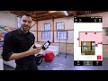
The BLK3D compact handheld imager by Leica Geosystems enables real-time, in-picture 3D measurements from any image captured. By combining measurement sensors, software, and on-device edge data processing capabilities, the BLK3D generates a complete and precise 3D record with every image captured. Whether it’s creating floor plans and estimating building installations or documenting construction progress and creating as-built facility documentation, professionals can now make faster decisions within their daily workflow.
To find out more about the BLK3D, and place an order, visit www.BLK3D.com
Видео How to capture reality with the Leica BLK3D канала Leica Geosystems AG
Показать
Комментарии отсутствуют
Информация о видео
Другие видео канала
 BLK3D Introduction to the Sketch and Document Function
 Leica Geosystems | DISTO™ S910 - P2P and CAD Integration
 BLK3D images processed in Agisoft Metashape (no reference measurements required for a scaled model!)
 Scaffolding Kolb works extremely effective with the Leica BLK3D
 Digitales 3D-Aufmaß an historischen Gebäuden
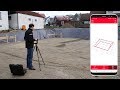 Leica DISTO™ Plan App - How to use the Earthworks Function
 Scanning with the BLK360
 Pomiary szkieletu 3D dalmierzem #Leica #Disto S910 w programie iCON Office - #BIM 3D
 Using BLK3D desktop software to take measurements from measurable images.
 RTC360 demo field
 Leica BLK3D Publisher
 Leica BLK3D - Complete Video
 Using Leica BLK3D for construction documentation
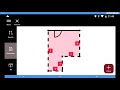 Leica BLK3D : Démonstration de l'appareil
 Leica BLK3D | Location Scouting Tech
 Intro to Scanning with BLK2GO
 Leica Disto S910: 3D Measurements
 Measuring from images with the BLK3D
 Demostración de Andy Fontana sobre Leica BLK360 con Leica Cyclone FIELD 360