花蓮市.佐倉步道 (Sakura Trail) , 猴子超多!佳山基地、奇萊平原
昔日台灣水泥的採礦道路, 在採礦結束之後, 蛻變成為一條生態健行步道,全長3950公尺,海拔爬升約420公尺。寬闊的步道路面, 讓人安步漫遊。步道蜿蜒而上, 沿途設有觀景平台, 可以俯瞰佳山基地, 時聞戰機嘯聲而起; 可以遠眺奇萊平原,望見太平洋無邊無際。步道旁的樹林, 時有獼猴蹤影,給遊客驚喜。
The former mining road of Taiwan Cement Corp. was transformed into an ecological hiking trail after the mining ended, with a total length of 3950 meters and an altitude climb of about 420 meters. The wide trail surface allows people to roam leisurely. The trail winds up, and there are viewing platforms along the way. You can overlook the Jiashan base, and you can hear the roar of fighter planes. You can overlook the Qilai Plain and the boundless Pacific Ocean. In the woods next to the trail, Formosan rock-monkeys are often seen, which surprises tourists.
本次旅行的交通資訊及旅行路線,請參考以下Google Map連結:
(Please refer to the following Google Map link for the traffic information and hiking route )
https://www.google.com/maps/d/edit?mid=1HP_hXmxL8f_tXLQfuZdCkAxty9nIdKc&usp=sharing
【一般路程時間參考】(Walking reference time)
去程約2小時, 回程約1.5小時 (含休息時間)。
The outbound trip takes about 2 hours and the return trip takes about 1.5 hours (including rest time).
【公廁資訊】(Lavatory Information)
步道入口及中繼站 (2990m) 設有公共廁所。
There are public toilets at the trailhead and relay station (2990m).
【交通資訊】(Traffic Information)
★大眾運輸:建議搭乘火車至花蓮站, 再轉乘計程車 (約4.5公里) 或步行約1小時至佐倉步道入口。
★自行開車:Google地圖衛星導航可以輸入「佐倉步道」 ,即可抵達目的地。步道入口設有停車場。
★Public transportation: It is recommended to take the train to Hualien Station, then transfer to a taxi (about 4.5 kilometers) or walk for about 1 hour to the Sakura Trail entrance.
★Driving by yourself: You can enter "Sakura Trail" on Google Maps satellite navigation to reach your destination. Parking is available at the trailhead.
【延伸閱讀】(Extended reading)
★Tony的自然人文旅記第2182篇 - 旅行影片:花蓮人的「看家山」~美崙山
https://youtu.be/bTAdGiLAT20
★Tony的自然人文旅記第1088篇 - 松園別館
http://www.tonyhuang39.com/tony1088/tony1088.html
★更多Tony的旅記, 歡迎造訪我的網站(旅記依旅行區域分類):
http://www.tonyhuang39.com/index1.html
【本次旅行GPX軌跡檔案下載】(GPX track file download for this trip)
https://www.waytogo.cc/xml/track/8/8/88319.gpx
http://www.tonyhuang39.com/00youtube/962.gpx
【影片製作相關設備及軟體】(Video production related equipment and software)
Gopro Hero 10 運動型攝影機 (攝影)
270-pro Backpack 碳纖維自拍桿 (自拍棒)
Waytogo app 記錄GPS 足跡 (行程記錄)
Power Director 365 威力導演 ( 剪接/字幕)
YouTube音效庫 (音樂)
PhotoImpact 13 (繪圖)
Google Map (交通地圖)
【音樂】(Music)
00:01 Back to Portland - TrackTribe (YouTube音樂庫)
02:25 Mourning Doves - Zachariah Hickman (YouTube音樂庫)
04:30 Pink Sunrise - The Great North Sound Society (YouTube音樂庫)
06:32 Christmas Homecoming - Aaron Kenny (YouTube音樂庫)
07:48 No.9 Esther Waltz (YouTube音樂庫)
Видео 花蓮市.佐倉步道 (Sakura Trail) , 猴子超多!佳山基地、奇萊平原 канала Tony Huang
Показать
Комментарии отсутствуют
Информация о видео
Другие видео канала
 全台規模最大、保存最完整的美軍宿舍—陽明山美軍宿舍群
 花蓮市~佐倉步道觀景平台, 眺覽奇萊平原美景
 福卯古道 (福隆車站~卯澳漁村) ,翻山越嶺,走向卯澳灣!
 花蓮市~撒固兒瀑布 (Sakul Waterfall)
 花蓮.新城神社 (縣定古蹟)、研海庄役場、信義路6號日式宿舍 (歷史建築)
 祕境景點—仁安磚窯廠八卦窯(新竹縣關西鎮)Secret Attraction—Ren'an Brick Kiln Factory Bagua Kiln (Hsinchu County)
 花蓮市.撒固兒步道 - 撒固兒瀑布、達部固灣事件的歷史回想
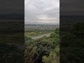 從大尖湖鎮福宮俯瞰大溪中庄, 宛如小型版的社子島 (Overlooking Zhongzhuang in Daxi from Zhengfu Temple in Dajianhu)
 萬里昭靈宮, 特殊的「西歷一八三八年」古碑刻字 (special inscription on the ancient stele "1838 AD"), New Taipei City
 瑪鋉溪步道親水平台 (新北市萬里區) (Masu River Trail Water Platform (Wanli District, New Taipei City)
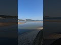 萬里瑪鋉溪河口, 萬里海水浴場, 遠眺野柳岬 (The estuary of Wanli Masu River, Wanli Beach, overlooking Yeliu Cape)
 縣定古蹟—北港水道頭文化園區十角水塔, 雲林縣北港鎮 (County-designated historic site—Decagonal Water Tower)
 國定古蹟—北港朝天宮夜景 (National Historic Site—Beigang Chaotian Temple Night View)
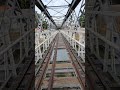 縣定古蹟—百年虎尾糖廠鐵橋, 雲林縣虎尾鎮(County-designated historic site—100-year-old Huwei Sugar Factory Iron Bridge)
 猴硐車站的貓咪坐看喧囂熙攘的旅客來來去去 (The cat at Houtong Station sits and watches the bustling passengers)
 新登山路線~隱身於東北角隆隆山區的「下坑古道」 (New mountaineering route ~ "Xiakeng Historical Trail", Longlong mountain)
 舊草嶺隧道自行車道, 長2166公尺, 曾經是台灣最長的隧道 (The old Caoling Tunnel bicycle path, 2166 meters in length
 鼻頭漁港, 位於東北角鼻頭角的美麗漁港 (Bitou Fishing Port, a beautiful fishing port located in the northeast corner)
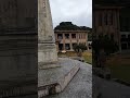 台灣唯一出現「蔣介石」名字的紀念碑在基隆要塞司令部 (The only monument with the name "Chiang Kai-shek" in Keelung
 釣客祕境—阿玉溪 (位於桶後林道0.8K處) Anglers’ secret spot—Ayu River valley located at 0.8K on Tonghou Forest Road