How to obtain a Basin and Channel Network from a No-sinks DEM in SAGA GIS and QGIS – Tutorial
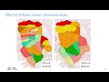
A basin is defined as a topographic region in which all water drains to a common area. Identifying basins within a study area can be beneficial for land and water management because priority areas can be defined and the hydrology of the area can be visualized. Delimiting a basin can be done by using Geographic Information Systems such as QGIS and SAGA GIS. To do so, a Digital Elevation Model (DEM) is required since the drainage network is determined by the elevation and slope of the terrain. This tutorial demonstrates how to reproject a DEM raster in QGIS, how to fill the sinks of a DEM, to calculate flow accumulation, to obtain the channel network and the basin limits with SAGA GIS based on the DEM using the Upslope Area interactive tool.
Видео How to obtain a Basin and Channel Network from a No-sinks DEM in SAGA GIS and QGIS – Tutorial канала Hatari Labs
Видео How to obtain a Basin and Channel Network from a No-sinks DEM in SAGA GIS and QGIS – Tutorial канала Hatari Labs
Показать
Комментарии отсутствуют
Информация о видео
Другие видео канала
 Deriving River Network & Catchments from a DEM using QGIS
 Stream and catchment delineation with GIS (theory)
 How to calculate Topographic wetness index using ArcGIS
 Очистка ЦММ от зданий и получение ЦМР в QGIS и SAGA GIS
 Qfield for QGIS # QGIS Tutorial
 Stream and catchment delineation in QGIS 3
 SAGA GIS TravelTime
 Mapping sediment flow using Landsat and DEM - SAGA GIS Tutorial
 Installing the "SAGA Next Gen" plugin in QGIS
 Calculate NDVI from Sentinel 2 and reclassify in QGIS
 Watershed Delineation in QGIS (Quickest & Easiest Tutorial)
 QGISHydro Webinar 4: Stream & Catchment Delineation
 Derive all subcatchments from a DEM using PCRaster in QGIS
 10 SAGA GIS Software Terrain Analysis
 1 - Delineating Watershed in QGIS
 QGIS 4 Arch - LiDAR to DEM with LASTools
 QGIS - Channels and Drainage Basins with SAGA
 Forest Cover Change Analysis - Landsat + SAGA GIS
![Introduction to PyQgis in QGIS 3 (Python Tutorial For Beginners) [FSW #11]](https://i.ytimg.com/vi/7DWKmu3pLAk/default.jpg) Introduction to PyQgis in QGIS 3 (Python Tutorial For Beginners) [FSW #11]
Introduction to PyQgis in QGIS 3 (Python Tutorial For Beginners) [FSW #11]