- Популярные видео
- Авто
- Видео-блоги
- ДТП, аварии
- Для маленьких
- Еда, напитки
- Животные
- Закон и право
- Знаменитости
- Игры
- Искусство
- Комедии
- Красота, мода
- Кулинария, рецепты
- Люди
- Мото
- Музыка
- Мультфильмы
- Наука, технологии
- Новости
- Образование
- Политика
- Праздники
- Приколы
- Природа
- Происшествия
- Путешествия
- Развлечения
- Ржач
- Семья
- Сериалы
- Спорт
- Стиль жизни
- ТВ передачи
- Танцы
- Технологии
- Товары
- Ужасы
- Фильмы
- Шоу-бизнес
- Юмор
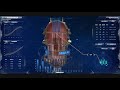
Smart City Government Affairs 3D Visualization Platform | Hightopo
The Smart City Government Affairs 3D Visualization solution is built on the HT for Web platform, integrating Hightopo digital twin, configuration monitoring and data visualization core technologies. It constructs a high-precision 3D panoramic digital model of the whole city, covering urban functional areas, government service facilities, infrastructure (transportation, water supply and power supply), public security points and ecological environments, realizing the integrated visual presentation of urban governance elements.
The system connects various government affair data systems, realizing real-time linkage and centralized display of government service data, urban operation indicators, public security situation, ecological environment data and emergency disposal information. It supports visualized management of government affair processes, real-time monitoring of urban operation status, and intelligent early warning of abnormal situations (such as traffic congestion, environmental pollution, and public security risks).
With Hightopo configuration monitoring and data visualization capabilities, key government affair indicators (service efficiency, urban operation quality, emergency response speed) are intuitively displayed through 3D urban scenes, dynamic data dashboards and trend charts. This solution helps government departments realize refined, visualized and intelligent urban governance, improve government service efficiency, optimize urban operation management, and empower smart city construction.
Видео Smart City Government Affairs 3D Visualization Platform | Hightopo канала Hightopo
Комментарии отсутствуют
Информация о видео
19 мая 2026 г. 8:05:21
00:00:24
Другие видео канала