Rockfall, Cliff Retreat in Yosemite Valley since Last Glacial Maximum
Video: https://www.usgs.gov/media/videos/rockfall-cliff-retreat-yosemite-valley-last-glacial-maximum
-----
The granitic cliffs of Yosemite Valley produce frequent rockfalls, modifying the landscape but also posing risk to park visitors. Analyses of terrestrial lidar and historical structure-from-motion photogrammetry data provide relatively precise short-term (approximately 40 years) rates of rockfall and cliff retreat. Those same data can also be used to estimate long-term (postglacial) rates through analysis of talus accumulation. Comparison of short- and long-term rates reveals complex spatial and temporal patterns of rockfall and provides a broader context for evaluating modern hazard conditions.
Stock G (2021) Pace of rockfalls and cliff retreat in Yosemite Valley since the Last Glacial Maximum. USGS Landslide Hazards Program Seminar Series, 27 October 2021.
Видео Rockfall, Cliff Retreat in Yosemite Valley since Last Glacial Maximum канала USGS Presentations
Показать
Комментарии отсутствуют
Информация о видео
Другие видео канала
 Global Change Monitoring Portal: Pilot for the Southeast US
 Climate Change and Migratory Species Presentation (Jan 2009) -- Part 1 of 3
 High Resolution Climate Models to Benefit Avian Conservation
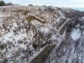 North Dakota landslide mapping: A complete inventory and mapping into the future
 PubTalk-01/2024: Ancient human footprints in North America during the Last Glacial Maximum
 PubTalk-09/2023 - Geothermal Energy Research: Goldilocks to Electricity With Earthquakes in Between
 Climate, Water Quality, Toxic Blooms of Golden Alga in Texas
 2017 October Evening Public Lecture — Global Trends in Mineral Commodity Supplies
 November Evening Public Lecture -- Waterbirds in a Changing Landscape
 Potential Corrosivity of Untreated Groundwater in the United States (Public Lecture)
 NextGen Water Data Update: Monitoring Location Pages & WaterAlert
 Atmospheric rivers cause the majority of precipitation-induced landslides in Western North America
 WaterML2 Part 3: Surface Hydrology Features Conceptual Model and the Mainstems Logistical Data Model
 The building and upkeep of landslide hazards program: Blue Ridge perspective on a national challenge
 USACE Huntington Use of USGS Data and Services
 topoBuilder: OnDemand, Custom, Topographic Maps
 Landslide risk evaluation: tools and tips for risky decisions
 Post-fire debris flows in relation to observed rainfall anomalies: Dolan Fire, California
 Use of UASs (“Drones”) in 2018 at Kīlauea and Beyond
 Fish Habitat and Climate Change Part 1
 Climate Change, Mountain Pine Beetles, and Whitebark Pine