Towboat Meetup in the Chain of Rocks Canal with Mention of the Drone Over the Radio
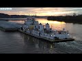
Well the drone got a comment on the radio lol. Anyway Retractable pilothouse. Length 100 feet. Breadth 34 feet. Twin screw towboat Built 1974 by Burton Shipyard, Port Arthur, TX. GM 16-645C diesels, repowered 1992, 3950 hp. Video recorded from Chouteau Island, Audio recorded from two different locations from these boats. Stick around to the end if you want some additional info.
By 1940, the locks and dams from Minneapolis down to Alton, Illinois, were in place and operational. The only challenge to navigation left on the upper Mississippi River was a series of rock ledges and shelves that extended for 17 miles on the north-east side of Saint Louis. Navigation through this area was impossible during lower water, and dangerous during high water.
To solve this problem, the US Army Corps of Engineers designed and built the Chain Of Rocks Canal to bypass this area. The canal ran from just south of the mouth of the Missouri River to just north of downtown Saint Louis. The canal cut across highway US-66, so a bridge had to be built over the canal. Later, when I-270 was constructed, a pair of big metal monster bridges were built just north of US-66.
Due to bedrock being so close to the surface, the canal could only be so deep. Since cutting through the rock would be dramatically more expensive, an alternate solution of providing a deeper channel was accomplished by building a dam across the Mississippi River just south of the entrance to the canal. This caused water to back up behind the dam, raising the level of the river by 3 feet, giving the canal an extra 3 feet of water depth. The dam across the Mississippi River did not need to provide for navigation. So rather than building an elaborate lock and dam structure, the US Army Corps Of Engineers simply dumped barge load after barge load of rock in the river. The water raises up behind the rocks, and then flows over the rocks.
Locks #27 are located at the south end of the canal. While the canal water level remains level at 400 feet above sea level, the Mississippi River drops nearly 15 feet in the 10 miles that are bypassed by the canal. As a result, a lock is required to maintain that difference in water levels.
https://www.patreon.com/user?u=22667511
https://www.mvr.usace.army.mil/Portals/48/docs/Nav/NavigationCharts/UMR/CHART_126.pdf
https://www.mvr.usace.army.mil/Portals/48/docs/Nav/NavigationCharts/UMR/CHART_127.pdf
Видео Towboat Meetup in the Chain of Rocks Canal with Mention of the Drone Over the Radio канала Bowzer's Towboat Channel
Показать
Комментарии отсутствуют
Информация о видео
28 ноября 2020 г. 21:26:37
00:10:49
Другие видео канала
 The Towboat Aaron F. Barrett Video Shot with DJI Mini 3 Pro
 The BIGGEST TOWBOAT on the MISSISSIPPI RIVER The M/V Mississippi
 Fishing Boat Fishing the Chain of Rocks
 The Towboat A. A. Birch III
 Towboat M/V Leviticus Southbound Illinois River at Hardin Illinois with Swallow Swarm
 The Towboat M/V Tom Behringer
 U.S. COAST GUARD SANGAMON
 Tuskegee Airman P-51C Landing KSET
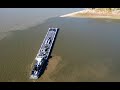 Low Water at Confluence of the Missouri & Mississippi River with Two Towboats
 Wreckage Of The USS Inaugural Low Water Mississippi River St. Louis
 Towboat Luke Burton in the Chain of Rocks Canal with Low Water and Pigeons Swarm Drone
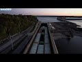 Dedicated to Lock and Dam 19 Keokuk Iowa
 Three Towboats at Tower Rock Mississippi River Low Water
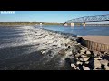 Mississippi River Chain of Rocks Low Water
 Walk to Tower Rock Low River Levels
 Dredge Goetz in the Chain of Rocks Canal Low Water
 The American Melody
 Towboat Titletown U.S.A. Northbound with Hip Barge
 Towboat Aurbrey B Harwell Jr Light Boat at Golden Eagle Ferry During Sunrise
 Golden Eagle Ferry Sunrise
 The New River Cruse Ship Viking Mississippi Northbound for Hannibal