- Популярные видео
- Авто
- Видео-блоги
- ДТП, аварии
- Для маленьких
- Еда, напитки
- Животные
- Закон и право
- Знаменитости
- Игры
- Искусство
- Комедии
- Красота, мода
- Кулинария, рецепты
- Люди
- Мото
- Музыка
- Мультфильмы
- Наука, технологии
- Новости
- Образование
- Политика
- Праздники
- Приколы
- Природа
- Происшествия
- Путешествия
- Развлечения
- Ржач
- Семья
- Сериалы
- Спорт
- Стиль жизни
- ТВ передачи
- Танцы
- Технологии
- Товары
- Ужасы
- Фильмы
- Шоу-бизнес
- Юмор
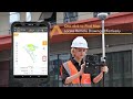
Satsurv Software Tutorial | Quick guide of GIS function
🗺🌍 **Mastering GIS just got easier!** Dive into the world of Geographic Information Systems with our latest video tutorial on **Quick Guide of GIS Functions**. Whether you're new to GIS or a seasoned pro looking to sharpen your skills, this guide is packed with everything you need to get started with Satsurv.
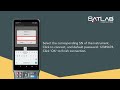
📱 **Interface Introduction**: Get acquainted with Satsurv's intuitive interface, designed to simplify your mapping tasks and boost your productivity.
🌐 **Online Map Setting**: Learn how to set up online maps to enhance your geospatial data visualization and analysis.
🔍 **Data Collection Made Simple**:
- **Point Collection**: Pinpoint accuracy at your fingertips.
- **Line Collection**: Draw lines and boundaries with precision.
- **Multi-layer Collection**: Manage complex data sets with ease.
.....
📤 **Data Export**: Take your data to the next level with Satsurv's efficient data export features.
#GISGuide #Satsurv #GeospatialData
Видео Satsurv Software Tutorial | Quick guide of GIS function канала SatLab
Комментарии отсутствуют
Информация о видео
26 сентября 2024 г. 15:30:23
00:08:13
Другие видео канала
![[Webinar] SatLab Lixel X1 Handheld SLAM Scanner - Real-time Mapping Solution](https://i.ytimg.com/vi/RVtvw5gM3Wc/default.jpg)