- Популярные видео
- Авто
- Видео-блоги
- ДТП, аварии
- Для маленьких
- Еда, напитки
- Животные
- Закон и право
- Знаменитости
- Игры
- Искусство
- Комедии
- Красота, мода
- Кулинария, рецепты
- Люди
- Мото
- Музыка
- Мультфильмы
- Наука, технологии
- Новости
- Образование
- Политика
- Праздники
- Приколы
- Природа
- Происшествия
- Путешествия
- Развлечения
- Ржач
- Семья
- Сериалы
- Спорт
- Стиль жизни
- ТВ передачи
- Танцы
- Технологии
- Товары
- Ужасы
- Фильмы
- Шоу-бизнес
- Юмор
LiDAR 3: LiDAR and AI
LiDAR 3: LiDAR and AI
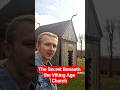
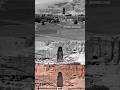
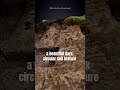
How do you find a Viking fortress you can't even see? Researchers mapped over 42,000 square kilometres of Denmark using Airborne Laser Scanning, which is precise enough to detect subtle elevation changes even under dense forest canopies. They trained an AI algorithm to hunt for circular features, using historic 18th-century maps and terrain data to filter out modern roundabouts and ancient ice-age craters
Reference and images: Stott, D., Kristiansen, S.M. and Sindbæk, S.M. (2019) 'Searching for Viking Age Fortresses with Automatic Landscape Classification and Feature Detection', Remote Sensing, 11(16), 1881.
#lidar #archaeology #history #vikings #vikings #fypage #fyp #archeology #ancienthistory #vikingage #technology #lidartechnology
Видео LiDAR 3: LiDAR and AI канала Marco Jørgensen
Комментарии отсутствуют
Информация о видео
13 марта 2026 г. 0:57:30
00:00:31
Другие видео канала