Hartbeespoort Dam Drone Tour
Hartbeespoort Dam Drone Footage
Captured using DJI Mavic Pro
Music by: Maxwell https://soundcloud.com/maxzwell
More about the dam:
Hartbeespoort Dam (also known as Harties) is an arch type dam situated in the North West Province of South Africa. It lies in a valley to the south of the Magaliesberg mountain range and north of the Witwatersberg mountain range, about 35 kilometers west of Pretoria. The name of the dam means "pass of the hartebeest" (a species of antelope) in Afrikaans. This "poort" in the Magaliesberg was a popular spot for hunters, where they cornered and shot the hartebeest.The dam was originally designed for irrigation, which is currently its primary use, as well as for domestic and industrial use. The dam has suffered from a hypertrophic state since the early 1970s. Mismanagement of waste water treatment from urban zones within the Hartbeespoort Dam catchment area is largely to blame, having distorted the food web with over 280 tons of phosphate and nitrate deposits.
The town of Hartbeespoort is situated close to the dam wall and the villages of Kosmos, Melodie, Ifafi, Meerhof and The Coves, Pecanwood, Westlake and several other estates can be found alongside its shores. The town of Schoemansville was named after General Hendrik Schoeman, owner of the land during the 19th century.
Видео Hartbeespoort Dam Drone Tour канала Emmanuel Nyoni
Показать
Комментарии отсутствуют
Информация о видео
Другие видео канала
 4 Bed House for sale in North West | Hartbeespoort Dam | The Islands Estate | 16 Lock P |
 Hartbeespoort Dam Wall (South Africa)
 Hartebeespoort Dam
 AERIAL CABLEWAY Hartbeespoort, South Africa Tourism
 Birthday Vlog: Things to do in Harties | Hartbeespoort | South African Youtuber
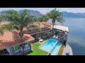 4 Bedroom House for sale in North West | Hartbeespoort Dam | Pecanwood |
 Is this the Most Beautiful Place In South Africa?
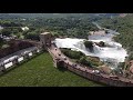 Hartbeespoort dam
 HARTBEESPOORT DAM (HARTIES), Johannesburg, South Africa Tourism
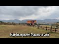 South Africa: Hartbeespoort places to visit | iPhone 12 & Nikon D5300
 10 TINY Micro Robots and Nano Drones
 6 Bedroom House for sale in North West | Hartbeespoort Dam | Westlake Estate |
 The Islands Estate
 The Islands Estate Video
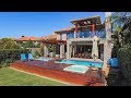 5 Bedroom House for sale in North West | Hartbeespoort Dam | Pecanwood |
 Luxury Living & Rural Develpment plans in South Africa Lekgalong, NW Province
 10 Most Insane Military Drones In The World
 30 Times Animals Messed With The Wrong Opponent !
 5 Bedroom House for sale in North West | Hartbeespoort Dam | Birdwood | 1048 Birdwood E |
 10 Biggest dams in South Africa