- Популярные видео
- Авто
- Видео-блоги
- ДТП, аварии
- Для маленьких
- Еда, напитки
- Животные
- Закон и право
- Знаменитости
- Игры
- Искусство
- Комедии
- Красота, мода
- Кулинария, рецепты
- Люди
- Мото
- Музыка
- Мультфильмы
- Наука, технологии
- Новости
- Образование
- Политика
- Праздники
- Приколы
- Природа
- Происшествия
- Путешествия
- Развлечения
- Ржач
- Семья
- Сериалы
- Спорт
- Стиль жизни
- ТВ передачи
- Танцы
- Технологии
- Товары
- Ужасы
- Фильмы
- Шоу-бизнес
- Юмор
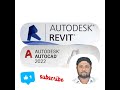
SCAN TO CAD: Complete Masterclass | 1-Hour Step-by-Step Reality Capture Workflow
🚀 SCAN TO CAD: Complete Masterclass | 1-Hour Step-by-Step Reality Capture Workflow
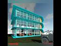
Welcome to the ultimate step-by-step masterclass on Scan-to-CAD and Scan-to-BIM processing! In this comprehensive, 1-hour video, we break down the exact industrial pipeline used to convert raw 3D laser scan data (Point Clouds) into highly accurate, production-ready 2D AutoCAD drawings and 3D Civil models.
Whether you are an infrastructure draftsman, a land surveyor, or an engineering specialist in the UAE, this video covers everything you need to know to optimize your daily workflow.
⏱️ VIDEO TIMESTAMPS
00:00 – Introduction to Reality Capture & Scan-to-CAD Workflows
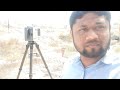
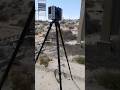
05:15 – Setting up Point Cloud Data in Leica Cyclone Register 360
12:30 – Understanding Point Cloud Classification (Ground vs. Noise)
18:45 – Exporting structured .RCP / .RCS data for Autodesk tools
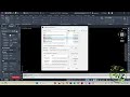
24:00 – Importing and Georeferencing Point Clouds in AutoCAD & Civil 3D
32:15 – Clean Extraction: Resolving the "20-Mile Extents" Limit Error
38:40 – Drafting Hardscape vs. Softscape Boundaries from Scans
46:20 – Automating Geometry Conversion using Custom AutoLISP (A2P)
52:10 – Building Tables, Cross-Sections, and Dynamic Data Fields
58:00 – Final Quality Check & Plotting Deliverables to RTA/DM Standards
🏗️ ABOUT ZM CAD ACADEMY
ZM CAD ACADEMY (a division of ZM CAD SOLUTION) is a leading corporate training provider specializing in advanced infrastructure engineering design, BIM coordination (LOD 100-500), 3D Laser Scanning (Scan-to-BIM), and GIS data systems.
We offer comprehensive training modules led by seasoned infrastructure sector professionals with hands-on, live-project experience.
🌟 Key Course Features:
Live Project Training using actual UAE coordinate systems.
Practical learning focused on industry-standard engineering submission workflows.
One-on-one professional doubt-clearing sessions.
Job-oriented training with an official Certificate of Completion.
📞 CONTACT US FOR TRAINING & SERVICES
Looking to upskill your team or collaborate on a reality capture project in the UAE? Get in touch with us today!
📱 WhatsApp / Call (Dubai, UAE): +971 55 908 3163
📱 WhatsApp / Call (Sri Lanka): +94 761 308626
🌐 Website: [Your Website URL]
📧 Email: [Your Email Address]
Видео SCAN TO CAD: Complete Masterclass | 1-Hour Step-by-Step Reality Capture Workflow канала ZM CAD
Welcome to the ultimate step-by-step masterclass on Scan-to-CAD and Scan-to-BIM processing! In this comprehensive, 1-hour video, we break down the exact industrial pipeline used to convert raw 3D laser scan data (Point Clouds) into highly accurate, production-ready 2D AutoCAD drawings and 3D Civil models.
Whether you are an infrastructure draftsman, a land surveyor, or an engineering specialist in the UAE, this video covers everything you need to know to optimize your daily workflow.
⏱️ VIDEO TIMESTAMPS
00:00 – Introduction to Reality Capture & Scan-to-CAD Workflows
05:15 – Setting up Point Cloud Data in Leica Cyclone Register 360
12:30 – Understanding Point Cloud Classification (Ground vs. Noise)
18:45 – Exporting structured .RCP / .RCS data for Autodesk tools
24:00 – Importing and Georeferencing Point Clouds in AutoCAD & Civil 3D
32:15 – Clean Extraction: Resolving the "20-Mile Extents" Limit Error
38:40 – Drafting Hardscape vs. Softscape Boundaries from Scans
46:20 – Automating Geometry Conversion using Custom AutoLISP (A2P)
52:10 – Building Tables, Cross-Sections, and Dynamic Data Fields
58:00 – Final Quality Check & Plotting Deliverables to RTA/DM Standards
🏗️ ABOUT ZM CAD ACADEMY
ZM CAD ACADEMY (a division of ZM CAD SOLUTION) is a leading corporate training provider specializing in advanced infrastructure engineering design, BIM coordination (LOD 100-500), 3D Laser Scanning (Scan-to-BIM), and GIS data systems.
We offer comprehensive training modules led by seasoned infrastructure sector professionals with hands-on, live-project experience.
🌟 Key Course Features:
Live Project Training using actual UAE coordinate systems.
Practical learning focused on industry-standard engineering submission workflows.
One-on-one professional doubt-clearing sessions.
Job-oriented training with an official Certificate of Completion.
📞 CONTACT US FOR TRAINING & SERVICES
Looking to upskill your team or collaborate on a reality capture project in the UAE? Get in touch with us today!
📱 WhatsApp / Call (Dubai, UAE): +971 55 908 3163
📱 WhatsApp / Call (Sri Lanka): +94 761 308626
🌐 Website: [Your Website URL]
📧 Email: [Your Email Address]
Видео SCAN TO CAD: Complete Masterclass | 1-Hour Step-by-Step Reality Capture Workflow канала ZM CAD
Комментарии отсутствуют
Информация о видео
30 мая 2026 г. 23:05:14
01:00:01
Другие видео канала