Volcanic Eruption in Iceland - Rare Footage (HD 720p)
www.kip.is offers Super-Jeep day-tours to the new Lava field of Holuhraun, seen in this video.
About the wind noise in the video:
I Wish I would had an external Microphone with a microphone cover. The Nikon D5300 has a built in mic and the settings for "Wind noise reduction" was off....
Please turn down the volume :)
28 Feb. 2015:
The Eruption is has stopped, it's over!!!
What is Lava? (http://www.kip.is - Daytours through volcanoes and lava fields)
Lava is made up of crystals, volcanic glass, and bubbles (volcanic gases). As magma gets closer to the surface and cools, it begins to crystallize minerals like olivine and form bubbles of volcanic gases. When lava erupts it is made up of a slush of crystals, liquid, and bubbles. The liquid "freezes" to form volcanic glass. http://volcano.oregonstate.edu/what-l...
19.2.2015. The lava field is now 85km²
3.2.2015: 'GMA' Flies Drone Over Erupting Volcano Live: https://gma.yahoo.com/gma-flies-drone...
29.01.2015: http://www.mbl.is/english/news/2015/0...
26. January 2015: News report http://youtu.be/IlQX1GHLKEg There is one thing not true in this news report from CCTV; There are no villages being evacuated. The eruption is in the middle of the highland, there is no one living there. yes there is sulfur-dioxide in the air in various places in Iceland coming from the eruption, depending of the direction of the wind, but it's not threat.
30. December 2014
http://www.mbl.is/english/nature_and_...
5. December 2014
An overview of the activity in Bardarbunga and the volcanic eruption in Holuhraun: http://avd.is/en/?p=726
21. December 2014
The lava field is now 80 square kilometers! http://avd.is/en/?page_id=521
10. september 2014
The lava field is now more than 70 square kilometers! http://avd.is/en/?page_id=521
7. september 2014
The lava field (upto 50 square kilometers) continues to grow. The subsidence of the Bárðarbunga caldera (~30m) continues, at slightly slower rate than before. Seismic activity in Bárðarbunga continues but with less large earthquakes. GPS measurements show minor movements.
It is estimated that the eruption produces 35,000 tons SO2 daily. Gas emissions at the eruption site are life threatening, gas masks and gas meters are required. There, local wind anomalies can occur due to thermal convection from the lava. This makes conditions on site extremely dangerous as winds can change suddenly and unpredictably. Dispersed, the gas can be detected elsewhere,
Þann 3. september 2014 fór ég sem myndasmiður fyrir fréttamiðil norðan heiða að gosstöðvunum norðan Dyngjujökuls. Ég hafði komið á þetta svæði á fjórða tug skipta í sumar og virkilega furðulegt að hafa eldgos í bakgarðinum hjá sér ef svo má segja. Þegar kyrrmyndatöku fyrir fréttamiðilinn var lokið tók ég þetta myndband fyrir sjálfan mig og vini til minja, einskonar "selfí". Nú hugsa ég að margir geti verið gramir sem ekki hafa fengið leyfi til að fara inn á svæðið, og finnist heldur fúlt að sjá mig taka þetta „selfí“ myndband. Fann vel fyrir hættunni og náði góðum myndum fyrir fréttamiðilinn áður en ég tók þetta myndband sem áður segir, til minja fyrir sjálfan mig og vini. Ég sé eftir að hafa ekki klippt það af örlítið meiri metnaði og haft hljóðnema með sokk, mig bara óraði ekki fyrir að þetta myndband yrði svo vinsælt. Hver veit nema maður geri aðra útgáfu sem inniheldur ekki andlitið á mér og klippt og unnið í heldur betri gæðum.
September 23: 2014: The volcanic eruption in Holuhraun continues with similar rate as last few days. The eruption does not seem to be declining. The lava production continues with the same strength. The lava flow is now around the centre of the lava field, which is now around 37 square kilometres.
According to new measurements the magma flow is 250-350 cubic meters pr. second.
The subsidence of the Bardarbunga caldera continues with same rate as before.
Big earthquakes are still detected in the Bardarbunga caldera. Since noon yesterday there have been 12 earthquakes bigger the M3, 0. The biggest one was measured M5,5 at 10:51 yesterday morning making it the second biggest earthquake since this wave of seismic activity started on August 16. Smaller earthquakes were detected in north part of the dyke and around the eruption site. Earthquakes up to M4 have been measured under the north-north-west slopes of Bardarbunga.
Most roads in Iceland are open and accessible including the Ring road (nr. 1) around Iceland and safe for travelling. However, due to the volcanic eruption in the area north of Vatnajökull glacier, the highland north of Vatnajökull glacier is closed for all traffic. The website on safe travel in Iceland www.safetravel.is is updated regularly and so are their information screens around Iceland. A live webcam of the eruption can be found at www.livefromiceland.is.
Видео Volcanic Eruption in Iceland - Rare Footage (HD 720p) канала Kristinn Ingi Pétursson
Показать
Комментарии отсутствуют
Информация о видео
4 сентября 2014 г. 13:54:35
00:09:04
Другие видео канала
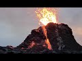 Fagradalsfjall Volcano 🌋 Iceland 60 minutes
 A Volcano Odyssey - Full Documentary
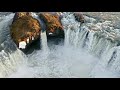 Waterfalls of Skjálfandafljót river (North Iceland)
 StrokkurGeyserVR180
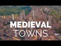 25 Most Beautiful Medieval Towns of Europe
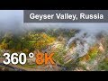 Valley of Geysers, Kamchatka, 8K aerial 360 video
 360° Kamchatka Volcano Eruption | National Geographic
 10 Awe-Inspiring Volcano Videos 🌋 Smithsonian Channel
 Iceland Untouched
 Driving Around Iceland - Day 4 - Laki to Landmannalaugar (F206, F208, Fjallabak, Highlands)
 Mýrdalsjökull Glacier and Katla volcano, Iceland
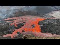 Geldingadalur Fagradalsfjall live lava river breach
 360 video. Uzon volcanic caldera, Kamchatka, Russia. 8K aerial video
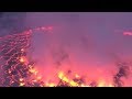 360: Inside DR Congo's deadly Nyiragongo volcano
 Fly Geyser (フライガイザー ) VR180
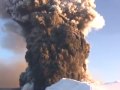 Eyjafjallajökull Eruption - helicopter flyover 17.april 2010
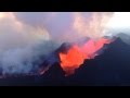 Holuhraun 20 september 2014
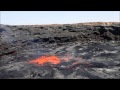 Erta Ale Lava Lake 2014
 Gorgeous 360 8K timelapse of the Milky Way rising over the Sonoran Desert
 360 video. Uzon volcanic caldera. Russian edition. 8K aerial video