Hiking in Oslo: Hammeren to Ullevålseter
Great hiking opportunities are just a short bus ride from downtown Oslo. A one-hour walk into the vast forest of Nordmarka that surrounds Oslo is Ullevålseter.
Ullevålseter is an old shieling/farm in the forest north of Oslo which has been converted into a ski lodge. It's a popular destination for hiking or trekking, both summer and winter. There is a cafe which serves refreshments and traditional Norwegian cakes.
The trip in this video starts at Hammeren in Maridalen. Bus 51 which goes from Nydalen in Oslo stops at Hammeren. We walked the gravel path past Skjærsjøen lake to Ullevålseter. It's also possible to take this road by bicycle, but motor vehicles are prohibited.
From Ullevålseteren we went back the same way, but it's possible to take other paths which will take you to Sognsvann or Frognersetern in Oslo.
If you want to walk only downwards, you can start by taking the metro (T-bane) to Frognerseteren. Then walk to Ullevålseteren, and then down to Hammeren from there.
For navigation, Google Maps on a mobile phone works great. Just enter navigation by foot to "Ullevålseter" in Maps.
Locations in Google Maps:
Hammeren: https://goo.gl/W72lvW
Skjærsjøen: https://goo.gl/llYG8R
Ullevålseter: https://goo.gl/Xrpavk
Видео Hiking in Oslo: Hammeren to Ullevålseter канала OsloPro
Показать
Комментарии отсутствуют
Информация о видео
Другие видео канала
 Oslo Travel Guide: Ekebergparken
 Hyperlapse: Karl Johans gate, Oslo, Norway
 Oslo Viewpoint: Grefsenkollen
 Oslo Island Hopping: Hovedøya and Langøyene
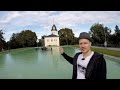 Oslo Travel Guide: St. Hanshaugen
 Hyperlapse: Aker Brygge, Oslo, Norway
 Oslo Nightlife: Underground bars
 Oslo Nightlife: Metal bars and rock venues
 Oslo Travel Guide: Beautiful photo spots in Oslo
 Oslo Travel Guide: Aker Brygge
 Hyperlapse: Thorvald Meyers gate, Oslo, Norway
 Oslo Travel Guide: Bogstadveien
 Oslo Travel Guide: Sørenga Seawater Pool
 The University of Oslo: Blindern Campus Guide
 Oslo Travel Guide: Things to do in Oslo as a Tourist
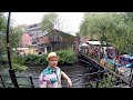 Oslo Travel Guide: Akerselva
 Oslo Travel Guide: Karl Johans gate
 Oslo Nightlife: Grünerløkka
 Fastest way from Oslo Airport Gardermoen to Oslo
 Oslo Travel Guide: Downhill sledding at Korketrekkeren