NASA | Earth at Night
In daylight our big blue marble is all land, oceans and clouds. But the night - is electric.
This view of Earth at night is a cloud-free view from space as acquired by the Suomi National Polar-orbiting Partnership Satellite (Suomi NPP). A joint program by NASA and NOAA, Suomi NPP captured this nighttime image by the satellite's Visible Infrared Imaging Radiometer Suite (VIIRS). The day-night band on VIIRS detects light in a range of wavelengths from green to near infrared and uses filtering techniques to observe signals such as city lights, gas flares, and wildfires. This new image is a composite of data acquired over nine days in April and thirteen days in October 2012. It took 312 satellite orbits and 2.5 terabytes of data to get a clear shot of every parcel of land surface.
This video uses the Earth at night view created by NASA's Earth Observatory with data processed by NOAA's National Geophysical Data Center and combined with a version of the Earth Observatory's Blue Marble: Next Generation.
http://earthobservatory.nasa.gov/NightLights
This video is public domain and can be downloaded at: http://svs.gsfc.nasa.gov/goto?11157
Like our videos? Subscribe to NASA's Goddard Shorts HD podcast:
http://svs.gsfc.nasa.gov/vis/iTunes/f0004_index.html
Or find NASA Goddard Space Flight Center on facebook:
http://www.facebook.com/NASA.GSFC
Or find us on Twitter:
http://twitter.com/NASAGoddard
Видео NASA | Earth at Night канала NASA Goddard
Показать
Комментарии отсутствуют
Информация о видео
Другие видео канала
 All Alone in the Night - Time-lapse footage of the Earth as seen from the ISS
 Top 10 International Borders That are Visible from Space
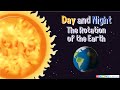 Day and Night – The Rotation of the Earth
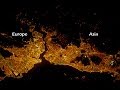 Top 50 City Lights Seen From Space
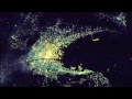 Part I: High-Res Images of Cities at Night (from ISS)
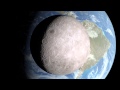 NASA | A View From The Other Side
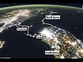 North Korea And South Korea From Space | Why Is North Korea Dark At Night? | Google Earth
 10 Countries at Night from SPACE
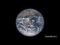 One Year on Earth – Seen From 1 Million Miles
 NASA | Take a "Swift" Tour of the Andromeda Galaxy
 Why There Is Light on Earth But Not in Space
 10 Space Photos That Will Give You Nightmares
 What Does The Earth Look Like From Deep Space? (NO FLAT-EARTHERS)
![Nocturne - Earth at Night [ 4k ]](https://i.ytimg.com/vi/8gPzIKe92-M/default.jpg) Nocturne - Earth at Night [ 4k ]
Nocturne - Earth at Night [ 4k ] Top 50 | Cities from Space | Part 1 - Night | Space Reloaded
 NASA Cassini's Final Images of Saturn Stunned Me
 Google Earth 3D Video Animation
 HOW IT WORKS: The International Space Station
 NASA | Earth from Orbit 2013