- Популярные видео
- Авто
- Видео-блоги
- ДТП, аварии
- Для маленьких
- Еда, напитки
- Животные
- Закон и право
- Знаменитости
- Игры
- Искусство
- Комедии
- Красота, мода
- Кулинария, рецепты
- Люди
- Мото
- Музыка
- Мультфильмы
- Наука, технологии
- Новости
- Образование
- Политика
- Праздники
- Приколы
- Природа
- Происшествия
- Путешествия
- Развлечения
- Ржач
- Семья
- Сериалы
- Спорт
- Стиль жизни
- ТВ передачи
- Танцы
- Технологии
- Товары
- Ужасы
- Фильмы
- Шоу-бизнес
- Юмор
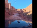
UT-24 Striped Fluted Cliff Jiffy between Hanksville & Torrey
Utah State Route 24: The Gateway to Capitol Reef
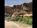
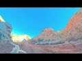
Utah State Route 24 (UT-24) is a major east-west highway in south-central Utah, spanning approximately 160 miles (257 km). It is famous for being one of the most scenic drives in the United States, cutting directly through the heart of Capitol Reef National Park.
Key Highlights & Landscapes
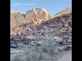
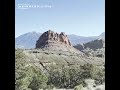
The highway is known for its dramatic geological shifts, taking travelers through a variety of "otherworldly" environments:
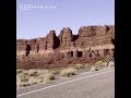
• Capitol Reef National Park: The road bisects the park, offering views of the Waterpocket Fold (a 100-mile wrinkle in the Earth's crust), towering sandstone cliffs, and the historic Fruita District.
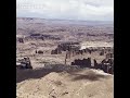
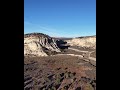
• The Lunar Landscapes (Hanksville): East of Capitol Reef, the terrain transforms into grey, volcanic-looking bentonite hills. This area is so reminiscent of the Red Planet that it hosts the Mars Desert Research Station.
• Factory Butte: A massive, solitary monolith that dominates the skyline near Caineville, often photographed for its stark, dramatic appearance.
Must-See Stops Along the Route
• Fruita Historic District: Historic orchards where you can pick fruit (in season) and the famous Gifford House pies.
• Hickman Bridge: A popular 2-mile round-trip hike leading to a massive natural sandstone arch.
• Petroglyph Panels: Easily accessible boardwalks where you can view ancient Fremont Culture rock art.
• Goblin Valley State Park: Located just north of UT-24, featuring thousands of mushroom-shaped rock formations called "hoodoos."
• Bentonite Hills: Vibrant, multi-colored clay hills that look best during "blue hour" (just before sunrise or after sunset).
Traveler Tips
• Fuel Up: Gas stations are very sparse between the towns of Torrey and Hanksville. Always start the drive with a full tank.
• Flash Flood Safety: UT-24 crosses several "washes." During heavy rain, these can flood instantly. Never attempt to cross a flooded road.
• Connectivity: Cell service is non-existent for large stretches of the highway. Download offline maps (like Google Maps) before heading out.
Route Overview
• Western Terminus: US-50 near Salina, UT.
• Eastern Terminus: I-70 near Green River, UT.
• Major Junction: Intersection with the famous Scenic Byway 12 in the town of Torrey.
Fun Fact: UT-24 is the longest contiguous state route in Utah, meaning it remains a single, unbroken numbered road for its entire length.
Видео UT-24 Striped Fluted Cliff Jiffy between Hanksville & Torrey канала unikUTAH
Utah State Route 24 (UT-24) is a major east-west highway in south-central Utah, spanning approximately 160 miles (257 km). It is famous for being one of the most scenic drives in the United States, cutting directly through the heart of Capitol Reef National Park.
Key Highlights & Landscapes
The highway is known for its dramatic geological shifts, taking travelers through a variety of "otherworldly" environments:
• Capitol Reef National Park: The road bisects the park, offering views of the Waterpocket Fold (a 100-mile wrinkle in the Earth's crust), towering sandstone cliffs, and the historic Fruita District.
• The Lunar Landscapes (Hanksville): East of Capitol Reef, the terrain transforms into grey, volcanic-looking bentonite hills. This area is so reminiscent of the Red Planet that it hosts the Mars Desert Research Station.
• Factory Butte: A massive, solitary monolith that dominates the skyline near Caineville, often photographed for its stark, dramatic appearance.
Must-See Stops Along the Route
• Fruita Historic District: Historic orchards where you can pick fruit (in season) and the famous Gifford House pies.
• Hickman Bridge: A popular 2-mile round-trip hike leading to a massive natural sandstone arch.
• Petroglyph Panels: Easily accessible boardwalks where you can view ancient Fremont Culture rock art.
• Goblin Valley State Park: Located just north of UT-24, featuring thousands of mushroom-shaped rock formations called "hoodoos."
• Bentonite Hills: Vibrant, multi-colored clay hills that look best during "blue hour" (just before sunrise or after sunset).
Traveler Tips
• Fuel Up: Gas stations are very sparse between the towns of Torrey and Hanksville. Always start the drive with a full tank.
• Flash Flood Safety: UT-24 crosses several "washes." During heavy rain, these can flood instantly. Never attempt to cross a flooded road.
• Connectivity: Cell service is non-existent for large stretches of the highway. Download offline maps (like Google Maps) before heading out.
Route Overview
• Western Terminus: US-50 near Salina, UT.
• Eastern Terminus: I-70 near Green River, UT.
• Major Junction: Intersection with the famous Scenic Byway 12 in the town of Torrey.
Fun Fact: UT-24 is the longest contiguous state route in Utah, meaning it remains a single, unbroken numbered road for its entire length.
Видео UT-24 Striped Fluted Cliff Jiffy between Hanksville & Torrey канала unikUTAH
Комментарии отсутствуют
Информация о видео
13 мая 2026 г. 16:56:07
00:00:06
Другие видео канала