- Популярные видео
- Авто
- Видео-блоги
- ДТП, аварии
- Для маленьких
- Еда, напитки
- Животные
- Закон и право
- Знаменитости
- Игры
- Искусство
- Комедии
- Красота, мода
- Кулинария, рецепты
- Люди
- Мото
- Музыка
- Мультфильмы
- Наука, технологии
- Новости
- Образование
- Политика
- Праздники
- Приколы
- Природа
- Происшествия
- Путешествия
- Развлечения
- Ржач
- Семья
- Сериалы
- Спорт
- Стиль жизни
- ТВ передачи
- Танцы
- Технологии
- Товары
- Ужасы
- Фильмы
- Шоу-бизнес
- Юмор
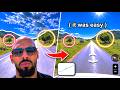
The internet couldn't find this house. How I did it with just 4 photos
This video is a walkthrough of a methodology for combining public geospatial datasets, satellite imagery, solar-angle analysis, and visual pattern recognition to study how environmental clues can be used in spatial investigations.
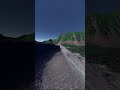
The workflow demonstrates how broad geographic assumptions can be tested and refined using non-invasive data sources such as parcel geometry, aerial imagery, historical imagery, lighting conditions, object-color detection, and land-use characteristics.
Certain details, maps, and location-specific visuals have been intentionally generalized or omitted to preserve privacy and keep the emphasis on responsible geospatial analysis.
Видео The internet couldn't find this house. How I did it with just 4 photos канала colsto
Комментарии отсутствуют
Информация о видео
17 августа 2025 г. 3:48:02
00:04:33
Другие видео канала