FARO and TopoDOT Road Survey workflow
Extracting civil/survey deliverables from a road scanned with the FARO Focus3D X 330. Thanks to the folks at TopoDOT for sharing this. They show extracting road, curb and gutter, hillside (DTM), and then the final 3D model.
Видео FARO and TopoDOT Road Survey workflow канала Matthew Daly
Видео FARO and TopoDOT Road Survey workflow канала Matthew Daly
Показать
Комментарии отсутствуют
Информация о видео
Другие видео канала
 Bridge As-built - FARO X330 Laser Scanner
 TopoDOT Automated Extraction
 BHB Land Surveying: Laser Scanner Demonstration
 TopoDOT Line-work in MicroStation to Civil3D Export
 How Langan have adopted TopoDOT to Manage, Assess & Extract features from point cloud data.
 Filtering Edge Noise in SCENE Advanced Tutorial
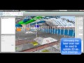 FARO Laser Scanning Introduction Contractors and Facility Owners
 Create Clean Ground Surface
 Survey for Road Project (Reconnaissance, Preliminary Survey etc) | Highway Engineering L-03| dAd Sir
 Utilizing Mobile and Aerial LiDAR datasets in TopoDOT
 QAQC of scans in FARO SCENE
 Pointly - Classify directly on a 3D point cloud, fast and simple.
 SCENE Webshare Cloud Intro Tutorial_FARO Focus3D
 Quantity Surveying course, know more,learn and earn
 What’s New in InfraWorks (2018.1) – Extract Linear Features from Point Clouds
 Laser Scanning Workflow Example Utilities and Piping
 TopoDOT - Auto Asset ID
 PLAN & PROFILE OF ROAD//HIGHWAY CONSTRUCTION
![A road survey with section lines [6 steps]](https://i.ytimg.com/vi/oy062wAP0o8/default.jpg) A road survey with section lines [6 steps]
A road survey with section lines [6 steps] Construction Estimation Costing and Quantity Survey Videos