Intro to Remote Sensing Workflows using ArcGIS
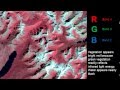
This video demonstrates a remote sensing workflow carried out in ArcGIS in which lakes in Kenya are mapped using Landsat satellite imagery.
Видео Intro to Remote Sensing Workflows using ArcGIS канала Jarlath O'Neil-Dunne
Видео Intro to Remote Sensing Workflows using ArcGIS канала Jarlath O'Neil-Dunne
Показать
Комментарии отсутствуют
Информация о видео
Другие видео канала
 Remote Sensing - Band Combinations
 QGIS Remote Sensing - Calculate NDVI
 How Does LiDAR Remote Sensing Work? Light Detection and Ranging
 RUS Webinar: Oil spill mapping with Sentinel-1 - OCEA03
 Generate Sample Plots and prepare Boundary Map in ArcGis10.5 (Nepali with Eng Subs) ArcGis Beginner
 What is Remote Sensing? Understanding Remote Sensing
 GIS metadata: A Technical Video Lecture
 Download and Extract Soil Moisture Data from Sentinel 1 and SMAP using ArcGIS Desktop
 ENVI Tutorial 4: Image Geometric correction
 Глушкова Г.В. Настройка интерфейса ArcGIS Desktop
 Normalized Difference Vegetation Index NDVI Geogrphic informations system ARCGIS - ESRI - GIS
 GIS Tutorial: Selecting Features Based on Location
 Watershed Delineation using Hydrology Tool in ArcGIS
 Introduction to ArcGIS Online (AGOL)
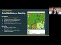 OpenTEAM In-Depth - Remote Sensing Methods for Measuring Soil Organic Carbon at the Field Scale
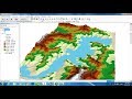 Showing Flood Flow By Animation in GIS || Showing Flood Flow in 3D DEM by Animation || Floodplain
 ArcGIS Online - How to add a field and edit values
 Landsat 8 Image Classification using QGIS
 SQL Query Tips & Tricks for GIS
 ArcGIS Photogrammetry for 3D Applications