Northeast Wisconsin Airborne Electromagnetic Survey 2021 - Helicopter and survey equipment takeoff
Helicopter with geophysical equipment loop deployed below it via slingload taking off for survey flight. In January 2021 a helicopter carried an airborne electromagnetic induction sensor over parts of northeastern Wisconsin as part of a USGS study to map the aquifers in the region. The data will be used to inform models of water availability and quality in the region that can be used by resource managers and policy makers. This video shows the equipment being deployed from a low-flying helicopter operated by specially trained pilots. In addition to the usual field safety procedures, USGS personnel are practicing COVID-19 safety measures including distancing and wearing face coverings during current field work. The project is a collaboration by the USGS Upper Midwest Water Science Center and Water Availability and Use Science Program with Wisconsin Department of Agricultural, Trade and Consumer Protection (DATCP); Wisconsin Department of Natural Resources (DNR); and Wisconsin Geological and Natural History Survey (WGNHS).
Video: https://www.usgs.gov/media/videos/northeast-wisconsin-airborne-electromagnetic-survey-2021-helicopter-and-survey
Видео Northeast Wisconsin Airborne Electromagnetic Survey 2021 - Helicopter and survey equipment takeoff канала USGS
Video: https://www.usgs.gov/media/videos/northeast-wisconsin-airborne-electromagnetic-survey-2021-helicopter-and-survey
Видео Northeast Wisconsin Airborne Electromagnetic Survey 2021 - Helicopter and survey equipment takeoff канала USGS
Показать
Комментарии отсутствуют
Информация о видео
Другие видео канала
 Landsat 8: 5-Year Anniversary
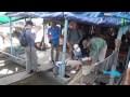 Forecast Mekong: Virtual River of Life
 Landsat Collections - RMSE
 February 14, 2023 — Continued lava lake activity at Kīlauea summit
 Living with Fire: Fire Decision Model
 I Am A...Wildlife Biologist
 Lake Powell Water Quality Samples at a Specific Depth
 Landsat in Action - Changing Forest Phenology with Andrew Elmore
 USGS Emergency Management 101 Onsite leadership and communication
 Vent that formed on the wall of Halema‘uma‘u crater, Kīlauea volcano — June 7, 2023
 Climate Science Champions, Season 1: Vanessa von Biela, Research Fish Biologist
 June 18, 2023 — Video of southwest wall vent in Halemaʻumaʻu
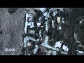 Living with Fire: Human Fire Ignitions
 NMIC - 2017 Mineral Commodity Summaries Release
 Lava fountaining in Halema'uma'u crater—October 12, 2021
 Collecting water data for the U.S.
 Churn Operation
 2011: The Year of the Flood
 Hatching an Engineer
 Advances in Streamgaging | Reach-Scale Monitoring Experiment (2 of 2)
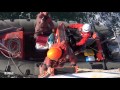 GEO XIV Plenary 2017