Build a 3D City in ARCHICAD using CADMAPPER, SKP & Google Earth Imagery
Learn how to create a 3D Site model in ARCHICAD using free GIS sources online, combined with Google Earth imagery.
Please subscribe if you like this content! http://bit.ly/2s75sGk
To ready more about this approach, check out the blog
https://www.contrabim.com/blog/3dcity-cadmapper
Intro: 6:30
Learn how to export GIS site data 12:26
Learn how to import Sketchup into ArchiCAD 19:30
Learn how to explode, and work with Morphs 22:30
Learn how to export Google Earth Imagery: 29:28
Learn how to texture map aerial images to topo surfaces 41:05
Learn how to create topo lines 49:45
Learn how to combine morph topography 56:30
Learn how to add elevations in google earth 58:50
And a bunch of other little tips and tricks along the way.
3Dconnexion Mouse: https://amzn.to/35ZSQ6m
Видео Build a 3D City in ARCHICAD using CADMAPPER, SKP & Google Earth Imagery канала CONTRABIM
Показать
Комментарии отсутствуют
Информация о видео
Другие видео канала
 How to Build 3D Site Logistics Plans
 Google Earth Maps to Archicad - Tutorial
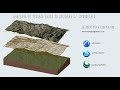 Terreno de google earth en archicad.
 Three Ways To Import OpenStreetMap Data In SketchUp
 ◄ FICTIONAL STARSHIPS Size COMPARISON ► 3D 🛸
 CITIES ON TERRAIN in Lumion 9
 City District Modeling - ARCHICAD
 Want to learn better? Start mind mapping | Hazel Wagner | TEDxNaperville
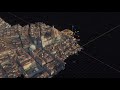 Importing Actual 3D Models From Google Maps
 ARCHICAD 23 Tutorial #2 Site Plan - SLOPED road, curbs
 How to create anything in ArchiCAD: Urban Surrounding for flight perspectives
 Create any City in Blender in 20 Minutes
 How To Create EXPLODED AXONOMETRIC Diagram | Archicad And Illustrator Tutorial
 Architecture Site Visualization | How to Model Terrain from Google Earth | ArchiCAD Tutorial
 Modeling a Voronoi Bridge in SketchUp!
 How to Model Shoring & Deep Excavations in ArchiCAD (Ep006)
 Topography for any Site with CADmapper - Revit Tutorial
 Moon in Google Earth - Apollo 11 Landing
 Cetopo: ArchiCAD + CetopoLoader Plugin
 SIMPLE TRICK ON ARCHITRAVE MODELLING IN ARCHICAD