- Популярные видео
- Авто
- Видео-блоги
- ДТП, аварии
- Для маленьких
- Еда, напитки
- Животные
- Закон и право
- Знаменитости
- Игры
- Искусство
- Комедии
- Красота, мода
- Кулинария, рецепты
- Люди
- Мото
- Музыка
- Мультфильмы
- Наука, технологии
- Новости
- Образование
- Политика
- Праздники
- Приколы
- Природа
- Происшествия
- Путешествия
- Развлечения
- Ржач
- Семья
- Сериалы
- Спорт
- Стиль жизни
- ТВ передачи
- Танцы
- Технологии
- Товары
- Ужасы
- Фильмы
- Шоу-бизнес
- Юмор
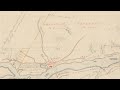
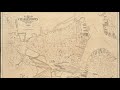
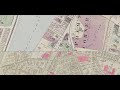
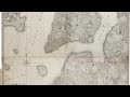
Brighton By Map
What was the name of the building that once housed the Brighton Branch? What was Brighton like in the late 19th and early 20th centuries? How has the area changed, and how has it stayed the same?
Using Atlascope, the Leventhal Map & Education Center’s user-friendly portal for exploring urban atlases, we’ll dive into the historical geography of Brighton. Come learn about how the community has changed over time, and discover how to research the history of your own house and neighborhood.
Видео Brighton By Map канала Leventhal Map & Education Center
Комментарии отсутствуют
Информация о видео
15 декабря 2021 г. 0:02:41
00:55:37
Другие видео канала