# 2 - Santa Clara Pueblo Creek Flash Flood - Daylight - 11 July 2012
After one year from the beginning date of the Las Conchas Wildland Fire (26 June 2011) in the Jemez Mountain Range, the threat of flash flooding along the Santa Clara Creek watershed still remains as a hazardous threat to the Tewa community. Film clips were taken a various location along the watercourse starting at the low water crossing in at the mouth of Santa Clara Canyon and ending near the drainage into the Rio Grande River.
Towards the last scene a backhoe tractor in reinforcing the embankment to prevent the waters from eroding the main community irrigation water system. Notice in the scenes the flood water looks a blackish color, this is due to the high ash sediment content and carries a strong odor of ash. Our Santa Clara Pueblo Forestry Division and other NM State and Federal Agencies have and continue to take recovery steps to reduce the post-fire runoff and the devastating effects of erosion. Their efforts include reseeding, mulching, channel treatments, contour log terraces, straw wattles, silt fences and other erosion risks reduction methods. Flash flooding will remain a threat in this watershed for the next 8 years until the vegetation can be re-established again.
Location from Water Cross-Over on Canyon Road at
Latitude N 35.58'30 W106.05'52 Elevation 5676
to the Two Waters Meet Road at
Latitude N 35.57'58 W106.04'50 Elevation 5582
a total of 1.5 mile in length and drop of 114 feet in elevation..
Видео # 2 - Santa Clara Pueblo Creek Flash Flood - Daylight - 11 July 2012 канала Greg Lonewolf
Показать
Комментарии отсутствуют
Информация о видео
Другие видео канала
 #4 Santa Clara Pueblo Flash Flood Event 01 Sept 2013
 El Paso, TX Flash Flood Waterfall 7/10/15
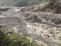 Overtopping failure of a large-scale artificial dam in Taiwan (Feng and Chen, 2012) - Part 2 Surge
 Warning!! Water level is going to rise.
 Mother Nature Angry Caught On Camera | Amazing Monster Flash Flood #2
 Flash Flood Fills 6 ft. Culvert on Cerrososo Road 7-8-13
 Unclogging our driveway culvert pipe. Complete with whirlpool.
 Historic Flash Flood in Zion National Park ~PEOPLE TRAPPED~ (The Narrows)
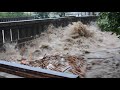 Flooding consumes central Schuylkill County, Pa. - 08/13/2018
 DIY Farm Road Repair
 Croatia Vrboska flooding tsunami high water boat
 Homestead Flooding, Creek Overflow, Driveway Washout
 Large Flash Flood / Debris Flow Buckskin Wash / Gulch 2013
 8 miles of the Los Angeles river in the San Fernando Valley
 07/28/2017 - Beginning of Monsoon Flash Flood - Santa Cruz River - Tucson AZ
 May 19th, 2015 (Disc Golf Park Flooding in Norman, OK)
 iGCSE Geography Flash Floods - Barèges, France.
 Iceberg Canyon Flash Flood (Flowing Ice!) - Lake Powell
 Alluvione in Piemonte - Valle Soana e Forzo - 3 Ottobre 2020
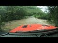 2018 Wrangler JL and Tropical Storm Olivia - Flash Flood