- Популярные видео
- Авто
- Видео-блоги
- ДТП, аварии
- Для маленьких
- Еда, напитки
- Животные
- Закон и право
- Знаменитости
- Игры
- Искусство
- Комедии
- Красота, мода
- Кулинария, рецепты
- Люди
- Мото
- Музыка
- Мультфильмы
- Наука, технологии
- Новости
- Образование
- Политика
- Праздники
- Приколы
- Природа
- Происшествия
- Путешествия
- Развлечения
- Ржач
- Семья
- Сериалы
- Спорт
- Стиль жизни
- ТВ передачи
- Танцы
- Технологии
- Товары
- Ужасы
- Фильмы
- Шоу-бизнес
- Юмор
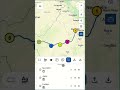
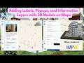
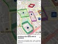
Turn 3D Building Models into Interactive Maps with MAPOG . #mapog #3dmodeling #3d #smarttools
Bring your 3D building models to life with MAPOG.
Upload your GLB, GLTF, or ZIP models and place them directly on live GIS maps with accurate positioning and full control over scale, rotation, pitch, zoom, and viewing angles.
Add project details, images, amenities, and nearby accessibility information to create interactive, presentation-ready experiences for real estate, infrastructure, and smart city projects.
✔ Upload & Place 3D Models
✔ Customize Views & Positioning
✔ Add Property Details & Images
✔ Share & Collaborate Instantly
✔ Create Interactive GIS Experiences
MAPOG makes 3D project visualization smarter, clearer, and more engaging.
🌐 Try Now: https://story.mapog.com?code=aff_0cf6487dd75e/?utm_source=Youtube&utm_medium=YoutubeShorts&utm_campaign=Mapstory
📩 Support: support@mapog.com
Like, Share & Subscribe for more GIS and mapping insights.
#mapog #3dmapping #gismapping #3DBuildings #interactivemaps #digitaltwin #geospatial #mapvisualization #SmartCityMapping #realestatetech #3dmodeling #InfrastructureMapping #3d #locationintelligence #gisplatform #spatialdata #3dvisualization #geotech #propertymapping #MapTechnology #gissoftware
Видео Turn 3D Building Models into Interactive Maps with MAPOG . #mapog #3dmodeling #3d #smarttools канала MAPOG
Комментарии отсутствуют
Информация о видео
20 мая 2026 г. 17:30:25
00:00:59
Другие видео канала