- Популярные видео
- Авто
- Видео-блоги
- ДТП, аварии
- Для маленьких
- Еда, напитки
- Животные
- Закон и право
- Знаменитости
- Игры
- Искусство
- Комедии
- Красота, мода
- Кулинария, рецепты
- Люди
- Мото
- Музыка
- Мультфильмы
- Наука, технологии
- Новости
- Образование
- Политика
- Праздники
- Приколы
- Природа
- Происшествия
- Путешествия
- Развлечения
- Ржач
- Семья
- Сериалы
- Спорт
- Стиль жизни
- ТВ передачи
- Танцы
- Технологии
- Товары
- Ужасы
- Фильмы
- Шоу-бизнес
- Юмор
Drone Photogrammetry Workflow Breakdown | 3D Mapping, Orthomosaic & Site Intelligence
#DroneMapping #Photogrammetry #Orthomosaic #DroneSurvey #AerialData
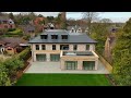
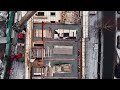
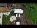
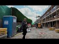
A quick voice-over walkthrough of a full drone photogrammetry workflow, showing how hundreds of overlapping aerial images can be processed into practical mapping outputs.
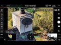
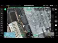
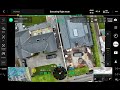
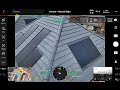
This project moves through multiple stages including:
• Photo alignment
• Tie point referencing
• Dense point cloud generation
• 3D mesh building
• Texture mapping
• Orthomosaic creation
• Digital elevation modelling
The result is a combination of visual and measurable outputs that can support planning, inspections, progress tracking and overall site visibility.
This video gives a behind-the-scenes look at that workflow from raw drone imagery through to final outputs.
FlyThrough Visuals
Aerial mapping, inspections and site intelligence for construction and development.
https://flythroughvisuals.com
Видео Drone Photogrammetry Workflow Breakdown | 3D Mapping, Orthomosaic & Site Intelligence канала FlyThrough Visuals
A quick voice-over walkthrough of a full drone photogrammetry workflow, showing how hundreds of overlapping aerial images can be processed into practical mapping outputs.
This project moves through multiple stages including:
• Photo alignment
• Tie point referencing
• Dense point cloud generation
• 3D mesh building
• Texture mapping
• Orthomosaic creation
• Digital elevation modelling
The result is a combination of visual and measurable outputs that can support planning, inspections, progress tracking and overall site visibility.
This video gives a behind-the-scenes look at that workflow from raw drone imagery through to final outputs.
FlyThrough Visuals
Aerial mapping, inspections and site intelligence for construction and development.
https://flythroughvisuals.com
Видео Drone Photogrammetry Workflow Breakdown | 3D Mapping, Orthomosaic & Site Intelligence канала FlyThrough Visuals
drone photogrammetry drone mapping orthomosaic mapping 3d drone mapping aerial survey drone survey photogrammetry workflow drone inspection drone mapping UK construction drone site intelligence orthomosaic dense point cloud digital elevation model drone surveying aerial mapping DJI enterprise DJI Matrice 4E FlyThrough Visuals construction technology
Комментарии отсутствуют
Информация о видео
4 ч. 50 мин. назад
00:04:18
Другие видео канала