Machine Control for Pile Driving
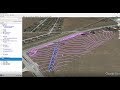
Carlson PDGrade the positioning software for piling applications such as solar, construction and other applications. The complete machine control for pile driving solution combines software and precision GPS technology -- creating a laser distance option for piling to an elevation, contour or pile depth for a complete pile machine guidance system.
Additionally, Carlson Command is the in-office software that provides site supervisors and managers with vital information from the field in real-time. Command connects the field to the office by allowing supervisors to upload projects to specific machines, send messages to operators, monitor machine status, and generate measurable reports.
Carlson Machine Control for Pile Driving is an all-in-one solution for solar contractors, solar farm installation, construction projects, and more.
Stop Guessing. Start Knowing.
For more information on Carlson for Pile Driving visit: https://www.carlsonsw.com/product/carlson-pdgrade
Видео Machine Control for Pile Driving канала Carlson Software
Показать
Комментарии отсутствуют
Информация о видео
Другие видео канала
 Takeoff R10 Webinar | Existing Ground and Sheet 1 of Design
 Carlson Geology | Contouring (Part 8/12)
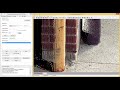 3) Carlson Point Cloud - Building Feature Extraction
 Carlson P3D Topo 2016 | Field to Finish
 1) Carlson Point Cloud - Importing and Map Preparation
 Working With PDF and BIM Files – Part 1
 Input-Edit Sections
 How to Export Surfaces and Points to Civil3D in Carlson 2020
 Introduction to Carlson 2019
 Carlson Geology | Other Resources (Part 12/12)
 Processing Drone Photos Carlson PhotoCapture Including Ground Control Points
 Quick Tour | Carlson Customer Portal
 Boundaries, Legal Descriptions, and Map Checks in Carlson Survey – Part 2
 Carlson Underground Mining | Underground Timing (Part 4/4)
 Przegląd funkcji cz. 4 - Menu COGO | Carlson SurvCE/SurvPC
 Learn Carlson Precision 3D Hydro 2021 Part 1 of 3: Intelligent TINS
 Carlson Geology | Other Modeling Concepts (Part 11/12)
 Point Deviations & Alignment Reports: the Power of Cutsheets
 Working between Carlson 2017 & P3D Hydrology
 Creating a Base Plan from Public Data
 Carlson Power Tools 1 – Polyline Elevation Editor