- Популярные видео
- Авто
- Видео-блоги
- ДТП, аварии
- Для маленьких
- Еда, напитки
- Животные
- Закон и право
- Знаменитости
- Игры
- Искусство
- Комедии
- Красота, мода
- Кулинария, рецепты
- Люди
- Мото
- Музыка
- Мультфильмы
- Наука, технологии
- Новости
- Образование
- Политика
- Праздники
- Приколы
- Природа
- Происшествия
- Путешествия
- Развлечения
- Ржач
- Семья
- Сериалы
- Спорт
- Стиль жизни
- ТВ передачи
- Танцы
- Технологии
- Товары
- Ужасы
- Фильмы
- Шоу-бизнес
- Юмор
How a “Lost World” Beneath the North Sea Went from Marginal Theory to Accepted Fact
# 🌊 Britain Wasn’t Dry Land — It Was a Waterworld
New video now live exploring the evidence behind the Post-Glacial Flooding Hypothesis and why archaeology may have fundamentally misunderstood prehistoric Britain.
This video examines:
• why rivers after the Ice Age were vastly larger than today
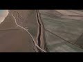
• how groundwater and flooding reshaped the landscape
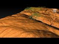
• why early settlements cluster on high ground
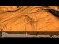
• the drowned world of Doggerland
• submerged forests, peat beds and buried river systems
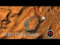
• why Stonehenge, Avebury and Britain’s dykes may only make sense through hydrology
• and how geology and archaeology may both have failed to connect the evidence together
The argument is simple:
**Rivers of the past were higher than rivers today.**
Once you understand that single principle, prehistoric Britain starts to look completely different.
This is not mythology or fantasy archaeology — it is an attempt to reconstruct ancient landscapes using hydrology, geomorphology, sea-level data, peat analysis, LiDAR and environmental evidence.
📚 Based on research from:
• *Post-Glacial Flood Britain Hypothesis – The Evidence*
• *The Stonehenge Computer*
• *Gigantic Prehistoric Canals (Dykes)*
• *Avebury’s Lost Stone Avenue*
🌍 Website:
https://prehistoric-britain.co.uk/clement-reid-doggerland-and-the-archaeological-establishment
#Stonehenge #Doggerland #Prehistory #Archaeology #Geology #Flooding #AncientBritain #Hydrology #LostCivilisation #Avebury #Megaliths #History #AncientHistory #Atlantis #IceAge #Britain #Science #LiDAR #PostGlacial #RobertJohnLangdon
Видео How a “Lost World” Beneath the North Sea Went from Marginal Theory to Accepted Fact канала Prehistoric Britain
New video now live exploring the evidence behind the Post-Glacial Flooding Hypothesis and why archaeology may have fundamentally misunderstood prehistoric Britain.
This video examines:
• why rivers after the Ice Age were vastly larger than today
• how groundwater and flooding reshaped the landscape
• why early settlements cluster on high ground
• the drowned world of Doggerland
• submerged forests, peat beds and buried river systems
• why Stonehenge, Avebury and Britain’s dykes may only make sense through hydrology
• and how geology and archaeology may both have failed to connect the evidence together
The argument is simple:
**Rivers of the past were higher than rivers today.**
Once you understand that single principle, prehistoric Britain starts to look completely different.
This is not mythology or fantasy archaeology — it is an attempt to reconstruct ancient landscapes using hydrology, geomorphology, sea-level data, peat analysis, LiDAR and environmental evidence.
📚 Based on research from:
• *Post-Glacial Flood Britain Hypothesis – The Evidence*
• *The Stonehenge Computer*
• *Gigantic Prehistoric Canals (Dykes)*
• *Avebury’s Lost Stone Avenue*
🌍 Website:
https://prehistoric-britain.co.uk/clement-reid-doggerland-and-the-archaeological-establishment
#Stonehenge #Doggerland #Prehistory #Archaeology #Geology #Flooding #AncientBritain #Hydrology #LostCivilisation #Avebury #Megaliths #History #AncientHistory #Atlantis #IceAge #Britain #Science #LiDAR #PostGlacial #RobertJohnLangdon
Видео How a “Lost World” Beneath the North Sea Went from Marginal Theory to Accepted Fact канала Prehistoric Britain
Комментарии отсутствуют
Информация о видео
19 мая 2026 г. 2:12:52
00:08:41
Другие видео канала