2010 Expedition to Titanic
In 2010, RMS Titanic, Inc. collaborated with some of the world's leading oceanographic and archeological professionals, in executing its eighth and most technologically advanced expedition to Titanic ever conducted. The expedition produced the first comprehensive survey map of Titanic, including imaging the bow and stern sections and her entire artifact debris field in high resolution sonar and 3D optical imagery. This data will form the basis of an archeological and site management plan in an effort to preserve Titanic, as well as to provide the public with the first-ever virtual picture of the ship in her current state.
Видео 2010 Expedition to Titanic канала Experiential Media Group
Видео 2010 Expedition to Titanic канала Experiential Media Group
Показать
Комментарии отсутствуют
Информация о видео
23 августа 2012 г. 1:54:17
00:01:39
Другие видео канала
 Titanic Archive Project: NOAA 2003 - Stern Flyover/Debris Field
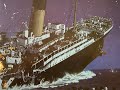 Titanic History/What caused the Titanic to Break up?
 Titanic Archive - 1957 Interviews
 Guernsey's Titanic auction
 Flying and Snorkeling on the SS Atlantic July 2012
 Titanic Expedition
 Who is RMS Titanic, Inc.?
 Lifeboats - What Equipments Inside? Launching & How do they work?
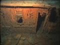 RMS Titanic Underwater NOAA Expedition - Kenny G (The Moment)
 Titanic: The Artifact Exhibition
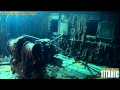 Remembering Titanic - Part One
 Virtual Tour of the Titanic Wreck | Guided Tour
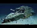 Why can't the Titanic be recovered from the bottom of the ocean
 R.M.S Olympic - The Story in HD/ Die Geschichte in HD
 Titanic Artifacts
 Lesson 10: Titanic's Linoleum!
 Olympic II Wreck in great vis!
 TITANIC Turkish Baths EXPLORATION
 Titanic Orlando
 Virtual Tour of the Titanic Wreck | Stern | Closer Look