How to merge drone images with terrestrial laser scans inside of RealityCapture.
In this tutorial, we will show you how you can align datasets of different origins like DSLR camera, drone camera, lasers scan etc. into one component.
We will show you that even when you have your datasets taken each other on different time you are able to align them together with RealityCapture.
We will show you two methods, one with control points and the other without the use of control points.
Try RealityCapture for free with PPI https://www.capturingreality.com/
Видео How to merge drone images with terrestrial laser scans inside of RealityCapture. канала Capturing Reality
Показать
Комментарии отсутствуют
Информация о видео
Другие видео канала
 Laser scanning: Chapter 3 of 3 - Simple Projects and Complex Projects
 Using Reality Capture PPI for Cheap
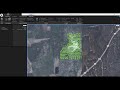 How to create georeferenced maps in RealityCapture - workshop
 Develop and Publish Flappy Bird in 3 Hours With Unity3D
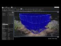 Import of Z+F laser scans by Zamani
 3D scanning with Reality Capture -Merging Componants
 Full Reality Capture — Combining UAS/Drone and Terrestrial Scans
 RealityCapture: Making a 3D model from photos and laser scans
 3D Scanning from video with Reality Capture
 Photogrammetry workflow with Tim Hanson, RealityCapture & CG Society
 How to Copy (almost) Any Object
 Photogrammetry 2 – 3D scanning with just PHONE/CAMERA simpler, better than ever!
 Component workflow in RealityCapture by CyArk - Part 1
 Reality Capture - Converting Photos to 3D Models
 Reality Capture Photogrammetry Webinar: sponsored by CGSociety.org
 Work with Control Points
 RealityCapture tutorial: Merging exteriors and interiors of buildings
 3D digital copy of interior by ArcTron | Extensive renovation
 RealityCapture Free Webinar: Advanced workflow for a combination of images and laser scans
 Features Preview: RealityCapture 1.1 Blaze