- Популярные видео
- Авто
- Видео-блоги
- ДТП, аварии
- Для маленьких
- Еда, напитки
- Животные
- Закон и право
- Знаменитости
- Игры
- Искусство
- Комедии
- Красота, мода
- Кулинария, рецепты
- Люди
- Мото
- Музыка
- Мультфильмы
- Наука, технологии
- Новости
- Образование
- Политика
- Праздники
- Приколы
- Природа
- Происшествия
- Путешествия
- Развлечения
- Ржач
- Семья
- Сериалы
- Спорт
- Стиль жизни
- ТВ передачи
- Танцы
- Технологии
- Товары
- Ужасы
- Фильмы
- Шоу-бизнес
- Юмор
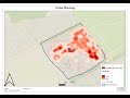
How to Download Vector and Raster Layers in QGIS | Beginner’s Guide to GIS Data Sources
Looking to download vector and raster layers for your GIS projects in QGIS? This video will walk you through the best sources to find and download GIS data, including both vector data (points, lines, polygons) and raster data (satellite imagery, digital elevation models). We’ll guide you step-by-step on how to download layers, import them into QGIS, and start building your map with real-world data!
In this tutorial, we’ll cover:
Popular Sources for GIS Data: Discover reliable websites where you can download free vector and raster data for QGIS.
How to Download Vector Data: Learn how to find point, line, and polygon data from resources like Natural Earth and OpenStreetMap to add boundaries, roads, and cities to your map.
How to Download Raster Data: Access detailed satellite imagery and elevation data using USGS Earth Explorer and integrate it into your QGIS project.
Importing Data into QGIS: After downloading, we’ll show you how to import these layers into QGIS and set up your map.
Where to Download GIS Data:
Natural Earth (for free vector and raster data): https://www.naturalearthdata.com
OpenStreetMap (for street-level vector data): https://www.openstreetmap.org
USGS Earth Explorer (for satellite imagery and elevation data): https://earthexplorer.usgs.gov
To get My Services on Fiverr:
1.do any gis mapping, spatial analysis, and data processing in arcgis or qgis
https://www.fiverr.com/s/e6V2NZE
2. Create SQL database design and queries
https://www.fiverr.com/s/1qkl725
3. automate your repetitive tasks, web scraping, and data processing with python
https://www.fiverr.com/s/AyDrdEQ
Whether you're a beginner or just looking for trusted sources for GIS data, this tutorial is packed with tips to help you get started. Make sure to subscribe for more QGIS tutorials and leave your questions in the comments below!
Видео How to Download Vector and Raster Layers in QGIS | Beginner’s Guide to GIS Data Sources канала Your Career in IT
How to download GIS data in QGIS Download vector layers in QGIS Download raster layers for QGIS Free GIS data sources QGIS tutorial for beginners Import vector data in QGIS Import raster data in QGIS GIS data download Natural Earth data download OpenStreetMap download tutorial USGS Earth Explorer tutorial GIS mapping tutorial Working with GIS data in QGIS QGIS data import guide
Комментарии отсутствуют
Информация о видео
3 ноября 2024 г. 23:20:00
00:25:10
Другие видео канала