How to georeference a shapefile in ArcGIS / Calibrate feature in ArcMap
Georeferencing shapefile using ArcGIS for Desktop
You want to use the "Spatial Adjustment" toolbar in ArcGIS, it works much like the georeferencing tool, but for vector data rather than raster. It can be applied to an entire layer at once, so you can create just a few control points (they're called "displacement links" in the spatial adjustment tool) and move every polygon in your layer.
Видео How to georeference a shapefile in ArcGIS / Calibrate feature in ArcMap канала Made 4 Geek
Показать
Комментарии отсутствуют
Информация о видео
Другие видео канала
 How to Delete X (Twitter) Account Permanently
 measure Distance on Google maps
 How to find Facebook forgotten password #facebook password
 How to view old story on Facebook
 Enable Dark Mode on Messenger Facebook
 Download hight resolution satellite image from USGS
 How to create mineral composite ratio map bands In ArcGIS
 how to recover and restore deleted messages in messenger Facebook #facebook
 Delete TikTok profile picture #tutorial #tiktok
 Page Numbers Starting at a Specific Page in Word 2019
 How to enable or disable dark mode in MS Word
 How to mosaic aerial imagery in ArcGIS Pro
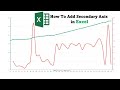 How to Create and Add a Secondary Vertical Axis in Microsoft Excel
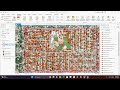 How to use Deep learning model in ArcGIS Pro to extract Trees and Building
 How to calculate Slope and Intercept of line in Excel
 How to Reclassify & Convert Raster DEM to Shapefile or Polygon & Smooth Contour Lines Using QGIS
 How To Extract WinRAR Files On Windows 11
 How to Delete TikTok Videos (2023 Update) | Delete a TikTok Video
 How to reclassify RASTER Layer in QGIS
 Install Facebook on laptop | Facebook App install on PC
 Georeferencing in qgis