Arun River अरुण नदी Leguwa लेगुवा Drone View
👇Booking open👇
Our services
🔹 Post Wedding | Pre Wedding
🔹Drone Service
🔹 Engagement | Wedding | Receptions
🔹 Rice feeding | Birthday | Baby Shoot
🔹 Music Video
🔹 Maternity shoot | Corporate events
🔹 Food photography
🔸 Attractive Packages available
Contact us: 9808034450
Photoberry Studio
Copying Video is Strictly Prohibited
The Arun River (Nepali: अरुण नदी) is a trans-boundary river and is part of the Kosi or Sapt Koshi river system in Nepal. It originates in Tibet Autonomous Region of the People's Republic of China where it is called the Phung Chu or Bum-chu.
The Arun is the largest trans-Himalayan river passing through Nepal and also has the greatest snow and ice-covered area of any Nepalese river basin. The Arun drains more than half of the area contributing to the Sapta Kosi river system but provides only about a quarter of the total discharge. This apparent contradiction is caused by the location of more than 80 percent of the Arun's drainage area in the rain shadow of the Himalayas. Average annual rainfall in Tibet is about 300 millimetres (12 in).[8]
The river leaves the Tibet region at a height of about 3,500 metres (11,500 ft) and crosses the main Himalayan ranges. Leaving their rain shadow, the river's flow increases substantially in the monsoonal climate of east Nepal. The landscape south of the border tends to be steep with less than 15 percent of the area having a sustained slope of less than 15° and is strongly dissected by stream channels. Many of the hill slopes are structurally unstable, and the region is seismically active. The August 1988 Nepal earthquake, with an epicentre more than 50 km south of the Arun basin, had a moment magnitude of 6.9 and resulted in more than 100 deaths in the basin alone.
The northern third of the Nepalese portion of the Arun basin supports a rich, though human-modified, forest of mixed hardwoods, Chir pine, fir, and rhododendron at elevations of over 1,000 metres (3,300 ft). The vegetation in the southern two-thirds of the area has been extensively modified for subsistence agriculture. Most of the half-million people in the Arun basin live in this southern area between 300 metres (980 ft) and 1,000 metres (3,300 ft) in widely scattered villages near the slopes they farm.
Видео Arun River अरुण नदी Leguwa लेगुवा Drone View канала Drone Man From Dharan
Показать
Комментарии отсутствуют
Информация о видео
Другие видео канала
 Pathivara Temple BhedetarII Nepal Drone Video II Eastern Nepal
 Dhankuta - Hile | Eastern Nepal (धनकुटा -हिले )
 Dharan 18 Drone View 2020 (Drone Video)
 DJI Phantom 4 pro V2 | How To Fix The video footage shaking | jello
 Bahubali Waterfall Nepal Kavre Drone View 2024
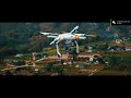 Drone Intro II Opening II Video II Drone Man From Dharan II
 Cinematic Video Of Different Part Of Nepal II Drone Video II 2020
 Beautiful Sunrise From Dhoja Dada Bazar
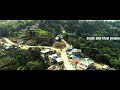 Ilam Shree Antu View II Nepal Drone Video II Eastern Nepal 2024
 Tilicho Lake Drone Video II Manang II Mustang II Nepal II
 Rupse Falls Mustang Nepal Skyview 4k
 Beautiful Dharan City From Takurea
 Beautiful Nepal II Visit Nepal
 Eastern Nepal Cinematic Drone Shot #dharan #easternnepal #dronevideo
 Udaipur Bangri Village Drone View Nepal 2019
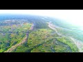 My Village From 1500 ft (Drone View) Phantom 4 pro V.2.0
 Mount Everest And Other Mountain from Sky
 Dharan Pindeshori Temple Drone View 4k
 Sarlai Bazar From Sky View
 Chatara Drone View on the way to Barahachhetra
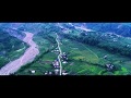 Thingabari Dharan 5 Halfway To Paradise || Nepal || Phantom 4 V.2.2 || 4K