Allowance for tidal streams
https://skippercheck.net/
Sailing School app https://apps.apple.com/app/sailing-school/id500663978
In order to allow for the set and drift of the tide and to calculate the Course to steer - we begin as follows
We will assume that our Ground Track is 045 degrees true.
Draw in the ground track A - B and mark it with two arrow heads.
Note: we use 1 arrowhead for the indication of a water track, 2 arrowheads for a ground track and 3 arrowheads for the tidal stream or current.
Now we check the Standard Port to which the tidal streams refer.
On the chart we find out that it is "Portsmouth".
With this information we enter the tide table.
We are interested in the morning High Water. The morning High Water on September 2nd is at 10:39 and the height is 4.3 meters.
To find out whether the rate of the tidal stream is a spring or a neap rate, we also have to take the height of the preceding Low Water into account, which is 0.1 meters.
To calculate the tidal range at this time we subtract the High Water from the Low Water.
Consequently the tidal range is 4.2 meters: 4.3 minus 0.1 meters.
Видео Allowance for tidal streams канала SkipperCheck
Показать
Комментарии отсутствуют
Информация о видео
Другие видео канала
 Обсервация пеленг и вертикальный угол секстанта 2
 методы спасения 2
 Aneroid barometer corrections 2
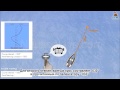 Применение девиации 2
 From Sailors to Shipbuilders: Exploring Latvia's Maritime Heritage
 Rescue techniques 3
 Маяки и буи
 The Must-Know Preparations for a Successful Helicopter Rescue from the yacht
 "Living on a Small Boat: Pros and Cons at the Marina"
 Cardinal marks 3
 Passage plan execution
 Basic GMDSS equipment
 Обсервация с двумя компасными пеленгами 2
 Cardinal marks, introduction
 Reading the nautical charts types and scales
 How to sail! Sailing & Boating Lessons - running fix plotting
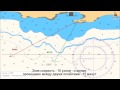 крюйс пеленг конструирование
 Fix position comb cross compass bearings comb cross compass bearings 2
 Implementation a towing vessel
 Обсервация дистанция и компасные пеленг 1