- Популярные видео
- Авто
- Видео-блоги
- ДТП, аварии
- Для маленьких
- Еда, напитки
- Животные
- Закон и право
- Знаменитости
- Игры
- Искусство
- Комедии
- Красота, мода
- Кулинария, рецепты
- Люди
- Мото
- Музыка
- Мультфильмы
- Наука, технологии
- Новости
- Образование
- Политика
- Праздники
- Приколы
- Природа
- Происшествия
- Путешествия
- Развлечения
- Ржач
- Семья
- Сериалы
- Спорт
- Стиль жизни
- ТВ передачи
- Танцы
- Технологии
- Товары
- Ужасы
- Фильмы
- Шоу-бизнес
- Юмор
NDVI with Landsat 8 & 9 in ArcGIS: Complete Tutorial
Learn how to calculate NDVI (Normalized Difference Vegetation Index) in ArcGIS using Landsat 8 and Landsat 9 imagery with the updated method using Collection 2, data from USGS Earth Explorer.
In this tutorial you will learn:
✅ How Landsat 8 & 9 band combinations differ from Landsat 7 for NDVI
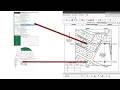
✅ Loading and preparing the correct bands (Band 4 & Band 5) in ArcGIS/ArcMap
✅ Using the Raster Calculator to apply the NDVI formula
✅ Classifying and symbolizing your NDVI result
This is the updated workflow for Landsat 8 and 9, and the band combinations diff from those of Landsat 7. This video will
clear up the confusion.
Perfect for GIS students, thesis projects, and environmental analysis,
vegetation monitoring, and remote sensing coursework.
⏱️ Chapters:
0:00 Introduction
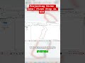
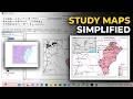
0:43 Explanation of NDVI Map and key requirements
1:38 Loading and preparing bands
2:00 Calculating NDVI with the Spatial Analyst Tool (Map Algebra)
3:20 Clipping of Study Area
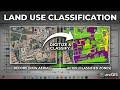
4:10 Classifying and symbolizing your NDVI output
🔔 Subscribe for weekly ArcGIS and GIS tutorials:
https://www.youtube.com/@Sir_Kwofae
📌 Related Videos that might interest you:
* NDVI with Landsat 7 in ArcGIS: https://youtu.be/xG2kj1eTOlg?si=h-suDUYQ2uMwBVs6
* How to Download Landsat Images for NDVI, LULC & LST Analysis: https://youtu.be/bCOghBdX4Q0?si=2DESLycYDxyjuNse
* Landsat 7 LST in ArcGIS (Collection 2): The Updated Method: https://youtu.be/A8ETZ5G0tts?si=e4WTK3RO09shd7VO
#NDVI #ArcGIS #Landsat8 #Landsat9 #GISTutorial #RemoteSensing #ArcMap
#NDVICalculation #GIS #SpatialAnalysis #VegetationIndex #LandsatNDVI
Видео NDVI with Landsat 8 & 9 in ArcGIS: Complete Tutorial канала Sir Kwofae
In this tutorial you will learn:
✅ How Landsat 8 & 9 band combinations differ from Landsat 7 for NDVI
✅ Loading and preparing the correct bands (Band 4 & Band 5) in ArcGIS/ArcMap
✅ Using the Raster Calculator to apply the NDVI formula
✅ Classifying and symbolizing your NDVI result
This is the updated workflow for Landsat 8 and 9, and the band combinations diff from those of Landsat 7. This video will
clear up the confusion.
Perfect for GIS students, thesis projects, and environmental analysis,
vegetation monitoring, and remote sensing coursework.
⏱️ Chapters:
0:00 Introduction
0:43 Explanation of NDVI Map and key requirements
1:38 Loading and preparing bands
2:00 Calculating NDVI with the Spatial Analyst Tool (Map Algebra)
3:20 Clipping of Study Area
4:10 Classifying and symbolizing your NDVI output
🔔 Subscribe for weekly ArcGIS and GIS tutorials:
https://www.youtube.com/@Sir_Kwofae
📌 Related Videos that might interest you:
* NDVI with Landsat 7 in ArcGIS: https://youtu.be/xG2kj1eTOlg?si=h-suDUYQ2uMwBVs6
* How to Download Landsat Images for NDVI, LULC & LST Analysis: https://youtu.be/bCOghBdX4Q0?si=2DESLycYDxyjuNse
* Landsat 7 LST in ArcGIS (Collection 2): The Updated Method: https://youtu.be/A8ETZ5G0tts?si=e4WTK3RO09shd7VO
#NDVI #ArcGIS #Landsat8 #Landsat9 #GISTutorial #RemoteSensing #ArcMap
#NDVICalculation #GIS #SpatialAnalysis #VegetationIndex #LandsatNDVI
Видео NDVI with Landsat 8 & 9 in ArcGIS: Complete Tutorial канала Sir Kwofae
ndvi calculation ndvi arcgis gis tutorial gis tutorial for beginners arcmap arcgis pro remote sensing remote sensing and gis gis landsat 8 landsat 9 landsat ndvi in arcgis calculate ndvi landsat 8 ndvi landsat 8 how to calculate ndvi how to perform ndvi how to ndvi in gis vegetation index normalized difference vegetation index ndvi map raster calculator arcgis usgs earth explorer spatial analysis land cover analysis gis youtube channel
Комментарии отсутствуют
Информация о видео
12 мая 2026 г. 17:20:31
Другие видео канала