- Популярные видео
- Авто
- Видео-блоги
- ДТП, аварии
- Для маленьких
- Еда, напитки
- Животные
- Закон и право
- Знаменитости
- Игры
- Искусство
- Комедии
- Красота, мода
- Кулинария, рецепты
- Люди
- Мото
- Музыка
- Мультфильмы
- Наука, технологии
- Новости
- Образование
- Политика
- Праздники
- Приколы
- Природа
- Происшествия
- Путешествия
- Развлечения
- Ржач
- Семья
- Сериалы
- Спорт
- Стиль жизни
- ТВ передачи
- Танцы
- Технологии
- Товары
- Ужасы
- Фильмы
- Шоу-бизнес
- Юмор
Why Every GIS Professional Needs Python | Beginner Python Crash Course | GIS Series
🐍 Python-Powered GIS | Day 2: Why Python for Geospatial Applications + Python Basics
In Day 1, we explored the world of Remote Sensing. Now it's time to bring in our primary tool — Python!
In this session, you will learn:
✅ Why Python is the go-to language for GIS and remote sensing workflows
✅ How Python compares to traditional GIS software like QGIS and ArcGIS
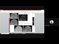
✅ How to download satellite data from the USGS Earth Explorer
✅ Core Python basics — variables, data types, loops, and functions — explained for complete beginners
No coding experience needed. We start from scratch!
📌 TIMESTAMPS
0:00 – Introduction & recap of Day 1
1:00 – Why Python for GIS? Key advantages
3:00 – Python vs traditional GIS tools
4:30 – Downloading satellite data from USGS Earth Explorer
6:00 – Python basics: variables, data types & syntax
8:00 – Wrap-up & what's coming in Day 3
🔗 SERIES PLAYLIST: [Link to Python-Powered GIS playlist]
📺 Day 1 (Introduction to Remote Sensing): [Link]
📺 Day 3 (Pandas, NumPy & Raster Band Calculations): [Link]
🛠️ TOOLS & RESOURCES
- Python 3.x (free download: python.org)
- USGS Earth Explorer: earthexplorer.usgs.gov
- QGIS (free & open source GIS software)
👩💻 ABOUT THIS CHANNEL
Hi, I'm Dr. Rashi Agarwal, Professor of Computer Science & Engineering at HBTU Kanpur, IEEE Senior Member, and AI/ML researcher. On this channel, I break down AI, machine learning, computer vision, and GIS — from beginner to research level.
🔔 Subscribe & hit the bell so you never miss a session!
📩 Drop your questions in the comments — I reply to every one.
#PythonGIS #PythonForBeginners #RemoteSensing #GISTutorial #GeospatialPython #USGS #EarthExplorer #GISPython #LearnPython #AIwithRashi #SatelliteData #GeospatialAnalysis
Видео Why Every GIS Professional Needs Python | Beginner Python Crash Course | GIS Series канала Learn Computer Science with Prof. Rashi
In Day 1, we explored the world of Remote Sensing. Now it's time to bring in our primary tool — Python!
In this session, you will learn:
✅ Why Python is the go-to language for GIS and remote sensing workflows
✅ How Python compares to traditional GIS software like QGIS and ArcGIS
✅ How to download satellite data from the USGS Earth Explorer
✅ Core Python basics — variables, data types, loops, and functions — explained for complete beginners
No coding experience needed. We start from scratch!
📌 TIMESTAMPS
0:00 – Introduction & recap of Day 1
1:00 – Why Python for GIS? Key advantages
3:00 – Python vs traditional GIS tools
4:30 – Downloading satellite data from USGS Earth Explorer
6:00 – Python basics: variables, data types & syntax
8:00 – Wrap-up & what's coming in Day 3
🔗 SERIES PLAYLIST: [Link to Python-Powered GIS playlist]
📺 Day 1 (Introduction to Remote Sensing): [Link]
📺 Day 3 (Pandas, NumPy & Raster Band Calculations): [Link]
🛠️ TOOLS & RESOURCES
- Python 3.x (free download: python.org)
- USGS Earth Explorer: earthexplorer.usgs.gov
- QGIS (free & open source GIS software)
👩💻 ABOUT THIS CHANNEL
Hi, I'm Dr. Rashi Agarwal, Professor of Computer Science & Engineering at HBTU Kanpur, IEEE Senior Member, and AI/ML researcher. On this channel, I break down AI, machine learning, computer vision, and GIS — from beginner to research level.
🔔 Subscribe & hit the bell so you never miss a session!
📩 Drop your questions in the comments — I reply to every one.
#PythonGIS #PythonForBeginners #RemoteSensing #GISTutorial #GeospatialPython #USGS #EarthExplorer #GISPython #LearnPython #AIwithRashi #SatelliteData #GeospatialAnalysis
Видео Why Every GIS Professional Needs Python | Beginner Python Crash Course | GIS Series канала Learn Computer Science with Prof. Rashi
Python for GIS Python geospatial why Python for remote sensing Python GIS beginners USGS Earth Explorer download satellite data download tutorial Python basics for beginners GIS tutorial Python geospatial Python tutorial Python vs ArcGIS Python vs QGIS learn Python GIS remote sensing Python Python introduction no experience Python-Powered GIS Python variables beginners Python data types geospatial analysis Python open source GIS Python
Комментарии отсутствуют
Информация о видео
18 мая 2026 г. 20:19:49
00:09:04
Другие видео канала