Exporting Your SketchUp Model to Google Earth - The SketchUp Essentials #28
Today's video will teach you to export your SketchUp model into Google Earth!
♦SUPPORT ME♦ http://www.patreon.com/thesketchupessentials
♦Courses♦ http://www.thesketchupessentials.com/courses
♦Website♦ http://www.thesketchupessentials.com
------------------------------------------------------------
In today’s SketchUp essentials tutorial, we’re going to talk about exporting your models to Google Earth.
We’ve talked a bit in the past about importing data from Google Maps into SketchUp to geolocate your model. Now, we’re going to talk about taking that geolocated model and exporting into into a Google Earth File.
This is especially important because it can allow you to see your shapes in context to the other buildings in the area.
First thing you’re going to do is geolocate your model. To do this, you’re going to go to the location toolbar and click the button labeled “add location.” This will pop up a window with a Map. Select the area you’d like, then click the “Grab” button.
This will import a map into your model, and it will also add a location to your model. You can see how now in the corner there’s a little red point, and if you mouse over it, there’s a note stating that “this model is accurately geolocated.”
Now you can come in here and create a building.
We’ll just make kind of a skyscraper type shape.
Now, once you’ve kind of modeled your building, you can go up to file, export, and export your file as a KMZ file.
A KMZ file is a geolocated file that Google Earth can read.
Now, open up Google Earth, and go select “Open.”
Open your file, and Google Earth will place it in your model.
The cool thing about this is that you can see your model in a geographic context.
This means that you can see exactly how tall your building would be in relation to other buildings, or how it sits on a site, etc.
You can also drop down into street level view and look up at your building to get a sense of scale.
You can also flip this on and off in order to get an idea of how the existing and proposed site relate to each other.
That’s where I’m going to end this video. Leave a comment below and let me know what you thought!
------------------------------------------------------------
PLEASE LIKE AND SUBSCRIBE
More SketchUp tutorials and resources at http://www.thesketchupessentials.com
Check Us Out On -
Twitter - http://www.twitter.com/easysketchup
Facebook - http://www.facebook.com/thesketchupessentials
Pinterest - http://www.pinterest.com/easysketchup/
Видео Exporting Your SketchUp Model to Google Earth - The SketchUp Essentials #28 канала TheSketchUpEssentials
Показать
Комментарии отсутствуют
Информация о видео
Другие видео канала
 How to Place a Sketchup Model in Google Earth
 The Top 5 FREE SketchUp Extensions Everyone Should Have!
 10 Ways to Create Curved, Rounded, and Organic Shapes in SketchUp
 TOP 10 Timesaving Tips for Layout (SketchUp and Layout Tutorial) - Save Time AND Effort!
 Site Modeling in SketchUp
 SketchUp GEOLOCATION and TOPOGRAPHY One Of My Most Popular Videos
 Three Ways To Import OpenStreetMap Data In SketchUp
 Introduction to Layout - The SketchUp Essentials #48
 Creating Floor Plans FROM IMAGES in SketchUp Free!
 3D Google Earth to Rhino Mesh - Digital Urban Photogrammety Workflow
 High Resolution Free Aerial Imagery in SketchUp
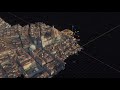 Importing Actual 3D Models From Google Maps
 Importing Google Map 3D to Blender / SketchUp / Lumion / TwinMotion
 4 Easy Ways to Import OpenStreetMap 3D Buildings into SketchUp (2021 Edition)
 Google Earth Pro + Agisoft PhotoScan_TUTORIAL ITA (A.A. 2016/17)
 Modeling Sliced Terrain from Location Data in SketchUp with Joint Push Pull and Slicer
 SketchUp Tutorial:Parametric Waffle Structure
 Import and Merge multiples Google Earth Aerial images in SketchUp
 Advanced Modeling WITH EXTRUDE TOOLS in SketchUp